![]() Ця сторінка також доступна українською.
Ця сторінка також доступна українською.
Ongoing research by Rohatyn Jewish Heritage and others has identified and located many Jewish heritage sites in the modern city of Rohatyn, and several are also included on commercial and city paper maps of streets and cultural features. On this page we provide an interactive map of all of the identified sites, followed by a list with GPS coordinates plus links to the relevant heritage pages on this website.
Read an introduction to Rohatyn’s immovable Jewish heritage.
First, the digital map:
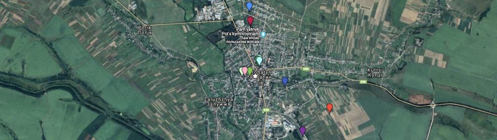
The image is interactive: pan and zoom are available with ordinary mouse controls or gestures, depending on the device, and zoom is also available by the +/- buttons in the lower left of the display. A white star identifies the town center, Roksolana Square, for reference. The heritage features and sites are listed below by category. A hyperlink in the title of each item redirects your browser to the relevant heritage page, if one exists. A hyperlink in the GPS coordinates redirects your browser to a Google Map with the item highlighted with a pin.
Jewish Religious Community Buildings and Sites
the first or “old” Jewish cemetery: 49.4077N, 24.6159E (49°24’27.7″N 24°36’57.2″E)
the second or “new” Jewish cemetery: 49.4199N, 24.6078E (49°25’11.6″N 24°36’28.1″E)
the main or “great” synagogue (destroyed): 49.4114N, 24.6100E (49°24’41.2″N 24°36’36.1″E)
a large beit midrash (ruin): 49.4112N, 24.6100E (49°24’40.4″N 24°36’35.8″E)
a small synagogue or cheder (ruin): 49.4111N, 24.6102E (49°24’40.0″N 24°36’36.9″E)
the western synagogue and mikveh (repurposed): 49.4094N, 24.6079E (49°24’33.8″N 24°36’28.4″E)
a bath house and Hebrew language school (repurposed): 49.4095N, 24.6060E (49°24’34.1″N 24°36’21.4″E)
see also the heritage page on recovered Jewish headstones and fragments
Sites of the Shoah
the wartime Jewish ghetto: see the heritage page (in progress)
the Judenrat office: 49.4094, 24.6066 (49°24’34.0″N 24°36’23.8″E)
the south mass grave and memorial: 49.4035N, 24.6276E (49°24’12.7″N 24°37’39.4″E)
the north mass grave and memorial: 49.4180N, 24.6080E (49°25’04.8″N 24°36’28.6″E)
Rohatyn’s train station and deportation site: 49.3997, 24.6215 (49°23’58.9″N 24°37’17.4″E)
the death camp at Bełżec: 50.3736, 23.4583 (50°22’25.0″N 23°27’29.9″E)
the hiding places in forests outside of Rohatyn: various; see the heritage page (in progress)
Modern Rohatyn Civic Sites (for reference)
Roksolana Square: 49.4097N, 24.6093E (49°24’34.9″N 24°36’33.5″E)
local history museum “Rohatyn Opillya”: 49.4086, 24.6108 (49°24’31.0″N 24°36’39.1″E)
This interactive map is one of a series of map-based information pages included in the project Mapping Rohatyn: Geography as a History Resource.