![]() Ця сторінка також доступна українською.
Ця сторінка також доступна українською.
Introduction
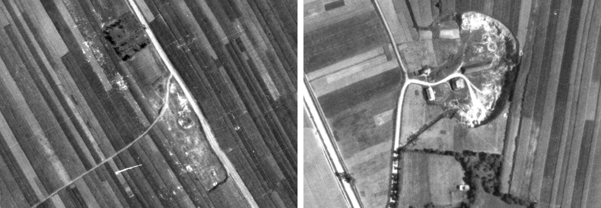
The mass grave sites, south (left) and north (right), seen in the 1944 Luftwaffe aerial photo.
The two wartime Jewish mass graves in Rohatyn are acknowledged and preserved by the town, but their location remote from the residential and business center of Rohatyn (likely a strategic decision by the occupying forces at the time of the killings) means that special attention is needed so that remembrance of the thousands of Jews who died at these sites is not lost. Official indifference under Soviet administration for decades after the war allowed local knowledge about the sites to dissipate; recognition of this wartime history in independent Ukraine demonstrates good will, but additional effort is required to recover or recreate specific knowledge of the sites. In the meantime, annual care of the memorial monuments and the grounds at each location is needed to protect and preserve the sites. Each site presents its own challenges due to its unique history, landscape, and surroundings; in this project, the south site and the north site are individually addressed in actions and schedules, but with common goals and some shared planning and resources.
Read about the history and heritage of the wartime mass killing and burial sites in Rohatyn.
Browse our news articles for coverage of events related to this project.
The goals of the Mass Grave Memorials Project are to:
- define the actual boundaries of the unmarked mass burial areas
- conserve and maintain the grounds and the existing monuments
- enhance the preservation, protection, and promotion of the grave sites
- coordinate with other information signage to guide visitors and to explain the history of the sites
- establish ongoing maintenance of the sites and their features
As described below, progress has already been made toward key goals of this project, including surveys and other investigations of the grave boundaries, and conservation of the grounds and memorial markers. As for our other projects, all RJH efforts will proceed with the continuing involvement of the Rohatyn city office and the office of the Rabbi of Ivano-Frankivsk.
Defining the Boundaries of the Mass Graves
Rohatyn’s south mass grave memorial site during non-invasive archaeological survey. Photo © 2017 RJH.
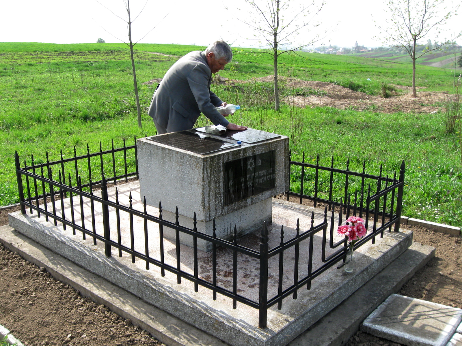
Two sets of memorials mark the places south and north of town where Jews from Rohatyn and surrounding towns and villages were murdered by the thousands; one pair of monuments is installed at each of the two locations where the killings and burials occurred. The first set of monuments was erected under Soviet administration, and remembers the victims of Fascism during World War II. The second set of monuments was erected by descendants of Rohatyn Jewish families in 1998, and was dedicated at a joint ceremony with the City and local religious leaders; these monuments specifically name the victims as Jews, and identify dates, numbers, and the local origins of the people who died there.
The actual perimeters of the burial grounds are not fenced or marked, and before RJH project work began, disagreement had persisted in town and among Jewish survivors and descendants about the precise locations and sizes of the grave boundaries. In mutual respect with the Rohatyn residents, farmers, and business people who avoid working and trampling on the graves, and to improve the commemoration and protection of the sites in partnership with the City of Rohatyn, Rohatyn Jewish Heritage prioritized the project to define the specific boundaries of the wartime grave pits.
Following preliminary research, discussions, and an exchange of historical documents (witness testimonies, historical photos, etc.), in 2016 RJH commissioned a non-invasive archaeological survey using ground-penetrating radar techniques by a professional team from the Centre of Archaeology at Staffordshire University (United Kingdom) of the two known mass grave sites (south and north) plus the new Jewish cemetery in Rohatyn. The site survey was conducted in late spring 2017; subsequent data assembly and analysis resulted in a final report at the end of 2017. This report and related information are linked below.
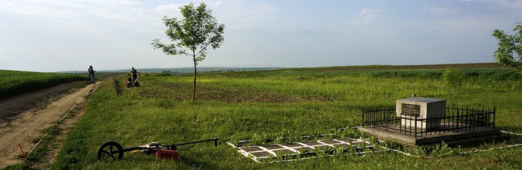
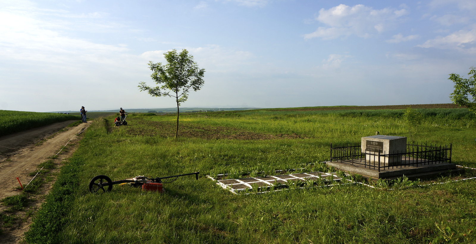
A panorama view at the south mass grave site during the 2017 survey. Photo © 2017 RJH.
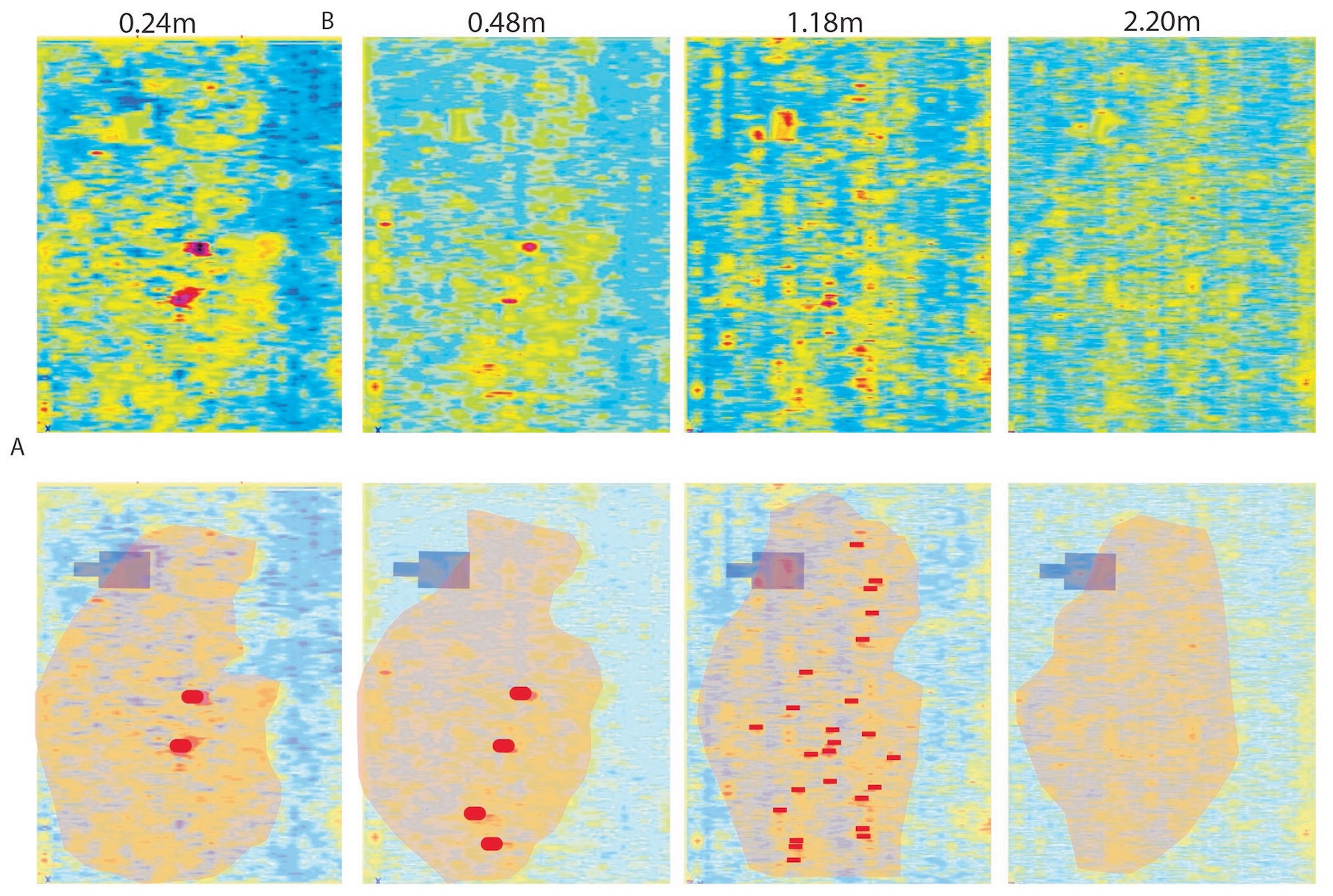
Sample data and analysis from the south site survey. Image © 2017 the Centre of Archaeology, Staffordshire University.
The intended territorial scope of the survey was agreed between the archaeologists and RJH based on historical documents and a review of the landscape at the sites. Unfortunately, the actual survey areas were smaller than planned, as nearly half of the intended survey area was not adequately cleared of vegetation and debris to permit passage of the radar antenna, and portions of the ground surface where measurements were made were too rough too obtain coherent measurements. However, within the reduced survey scope, one mass grave was identified with good confidence and clear boundaries at each of the sites, and another, possible grave was identified at the north site.
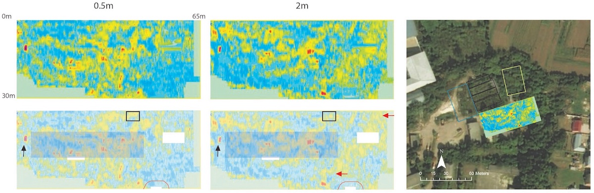
Sample data and analysis from the north site survey. Image
© 2017 the Centre of Archaeology, Staffordshire University.
These results provide new information about the actual boundaries of graves at the two locations, and also document other measured areas as likely without wartime graves, so that future work at the sites can be considered (both for commemoration and protection of the graves, and for other uses where no graves are present).
The supplemental north grave area identified by the former manager. Photo © 2018 RJH.
Half a year after the non-invasive survey, in the first week of 2018 we were introduced to a retired manager of the “vodokanal” facility where the north mass graves are situated, and learned via interview that he had personally seen human remains unearthed in the 1980s at two additional locations at the site, between and beside the radar grid areas of the 2017 survey. The former manager was quite certain about the locations of unearthed remains relative to the built and natural features of the site, though not the extents and boundaries of these additional graves. In May 2019, the Staffordshire team returned to the north grave site with radar equipment to survey this supplemental area; their subsequent analysis identified one likely additional grave pit with defined location, size, and depth, and a less distinct possible second pit.
The reports and data available to date are linked here:
- an RJH summary of the 2017 archaeology survey and report on both mass grave sites
- the archaeologists’ full 2017 report on both mass grave sites
- an RJH summary of the 2018 interview about the additional grave area at the north site
- the archaeologists’ supplemental report on the 2019 survey at the north grave site
A large selection of the primary report data images, plus our original 2016 request and documentation summary, and the archaeologists’ proposal, are also linked publicly to the summary page above.
Setting up a survey grid at the north site. Photo © 2017 RJH.
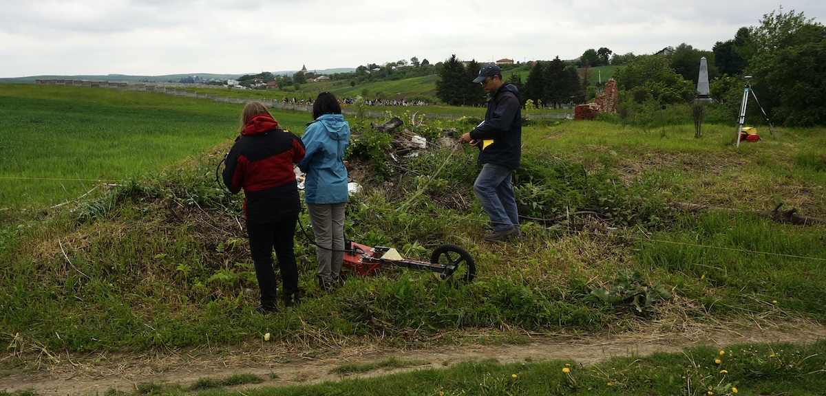
The archaeologists working around debris at the south site. Photo © 2017 RJH.
Although some grave areas have been defined with reasonable precision and confidence at both the south and north sites, and other areas have been identified as without graves, if funding can be secured, RJH will consider returning to both sites to conduct additional work at some point in the future. More intensive ground preparation (clearing rubble, garbage, and vegetation) in areas adjacent to the original survey grids will be required to extend the survey scope out to the full extent identified based on document and landscape analysis, and possibly different survey technologies will be required to overcome limitations of GPR analysis in the presence of heavy underground clay layers. No specific plans or schedules for this extension of the work is currently planned or scheduled by RJH or others.
Conservation of Existing Monuments and Grounds
Mr. Vorobets at work. Photo © 2013 RJH.
Both the Soviet monuments and the descendants’ monuments were designed and constructed well, and are aging gracefully; they are roughly 40 and 20 years old, respectively. Occasionally a portion of the surface on one of the monuments cracks or fails due to weathering, and there are other signs on the monuments from past decay and repair. The most recent report of damage was in April 2013, to the Soviet monument at the southern mass grave site; that damage has since been repaired by local concrete workers under the direction of local historian Mykhailo Vorobets and using RJH program funds. No further decay or damage has been observed at any of the markers since then, through 2018.
As the memorial markers appear stable, apart from inspection no specific conservation work is planned for the coming years, and funding for any future repairs will come from the RJH general fund. We anticipate the need for ongoing periodic inspection and occasional repair work, at what will probably remain low cost for the foreseeable future. If other heritage work including signage brings more visitors to the sites, we may need to consider an increased repair and maintenance schedule.
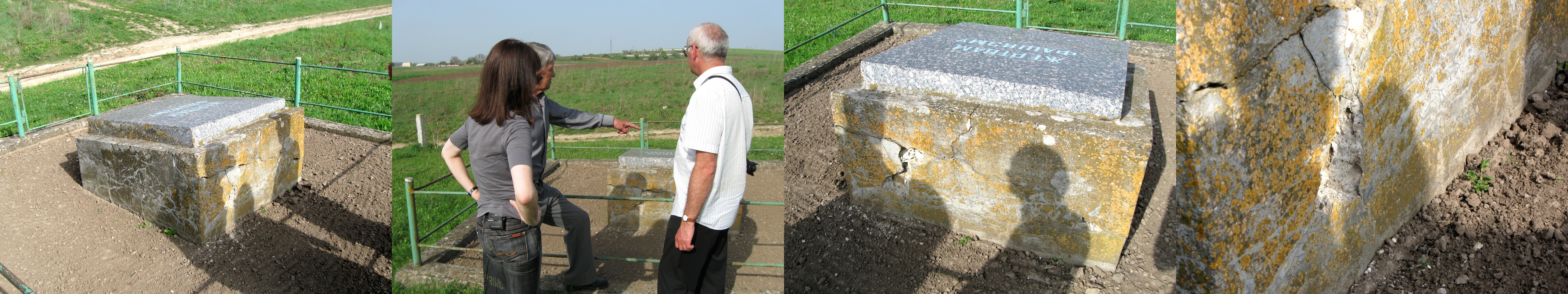
Inspecting age-related decay of the southern Soviet monument. Photos © 2013 RJH.
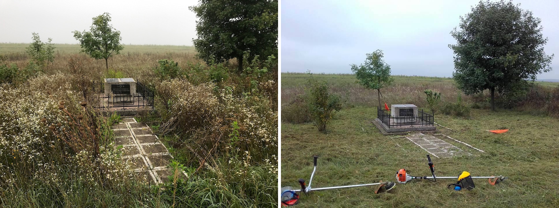
Before and after grounds work at the south mass grave memorial. Photos © 2018 RJH and TMF.
Because the ground around the existing mass grave monuments and over the actual mass grave areas is intentionally not used for industrial or agricultural purposes by Rohatyn residents and by the City, the soil tends to produce tall grasses, weeds and fast-growing brush on an annual basis. Mr. Vorobets cleared the soil and planted flowers within the marked monument borders for the past two decades through 2018, when he became too aged to continue as a volunteer, and local farmers have occasionally burnt off the wild growth outside of the planted areas when they prepare their adjacent fields on an annual cycle. Beginning in 2018, RJH began mechanically clearing a wider area around the several monuments, and in 2019 RJH contracted with a local man to replace Mr. Vorobets in regular clearing and planting within the perimeters of the memorial monuments.
Preservation, Protection, and Promotion of the Grave Sites
Clear definition of the mass grave boundaries will enable improved protection of the sites and the development of enhanced memorials to commemorate the victims of the wartime killings and the lost Jewish community of Rohatyn. Importantly, the data will allow RJH and the City of Rohatyn to better mark the graves as burial grounds bounded by visual elements which signify the special, sacred nature of the spaces.
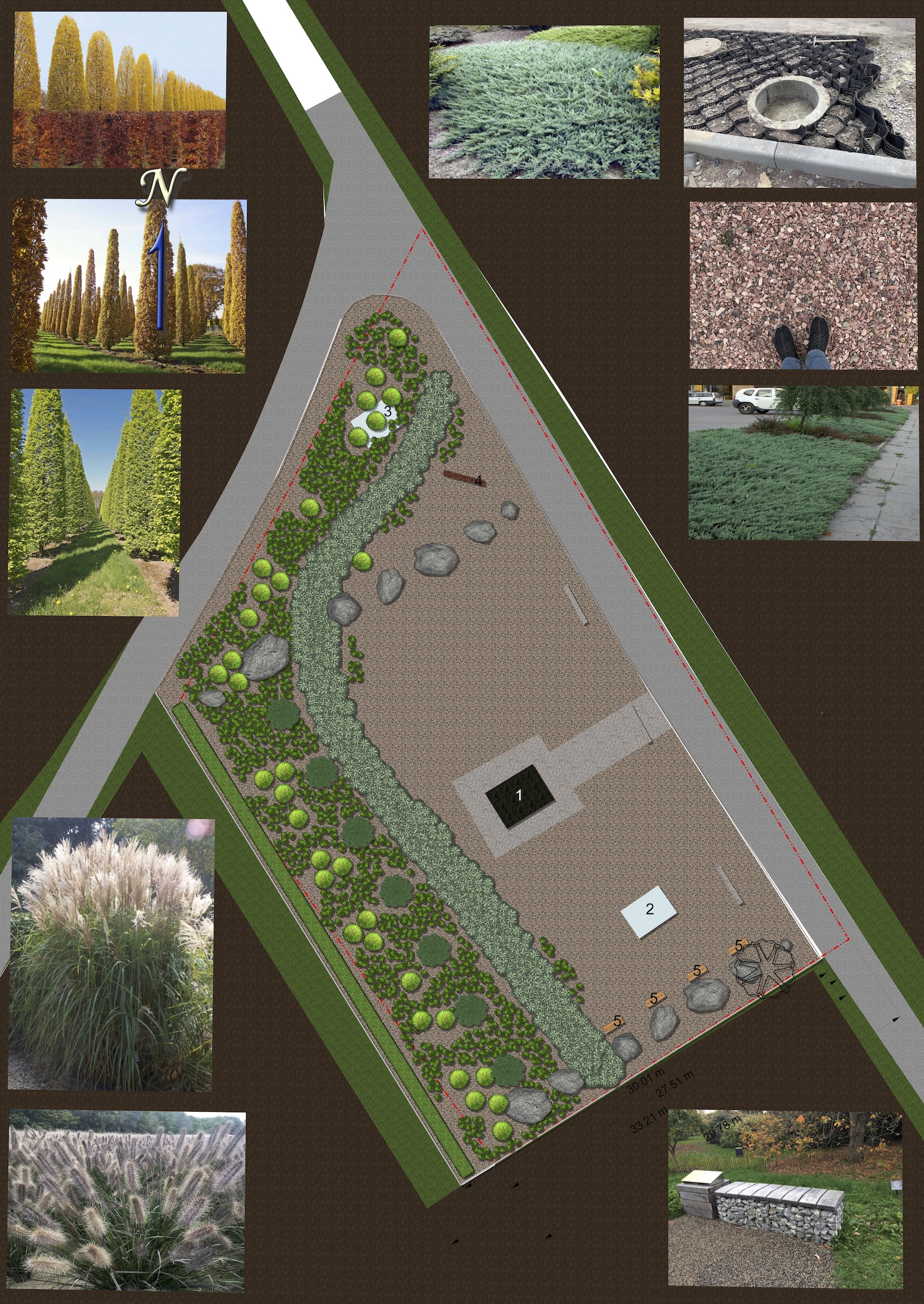
Visual elements of the general plan for the south grave site.
Image © 2019 Green Garden.
At the south site, the defined grave boundaries extend outside the rectangular area which are informally marked with concrete posts, but is within the larger rectangular area historically set aside by local farmers as cemetery ground. At present there is no visual indication at the site of the actual burial area. A key imperative for protection at this site is to deter looting of the grave, an ongoing problem which requires both law enforcement and local administrative action. We anticipate that enhancing the landscaping and signage at the site will effectively resolve this issue, as well as improve the experience of visitors who arrive with only a partial understanding of the site’s significance.
In 2019, Rohatyn Jewish Heritage commissioned an exploratory design for landscape architecture at the south site to address ongoing security and maintenance concerns and to enhance the visitor experience. The design work included a geodesic survey of the land within and around the grave boundaries, including the adjacent road, as well as site planning for rainfall and erosion control, infrastructure for green plantings and hard materials, transfer of the existing Jewish monument to center it within the actual grave boundaries, identification of specific plant species to create new visual lines, and an outline for prominent signage identifying and explaining the site with QR-code links to further information online. A detailed materials and labor list too support implementation planning was also included. Due to its high estimated cost, RJH will not implement the design as defined in 2019, but we will evaluate alternative designs, materials, and strategies in 2020 to hopefully support the implementation of a feasible plan in the future.
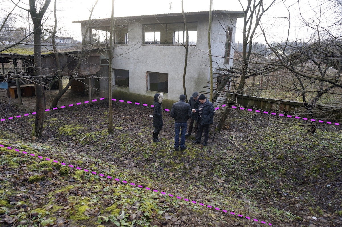
At the north site, the defined grave areas lie within an area which extends from beneath the existing memorial monuments to points some 50m away and in essence to the base of the steep hillside at the back of the vodokanal facility. One small built structure (currently used by a facility guard) is entirely enclosed within this combined grave area, and another abandoned building plus part of the former greenhouse complex directly abut the grave area. The City of Rohatyn, which owns the vodokanal facility, is aware of the archaeological and other findings at the site and avoids any development work there. Because the City maintains continuous security at the site, the graves are at no risk today even though there is no perimeter marking of the boundaries. Both Rohatyn Jewish Heritage and the City are interested in improving access for visitors and information at the site, in the form of an enhanced memorial space. Because of the likely high cost to rehabilitate this area and transform it into a welcoming space for reflection, any designs will require careful planning with serious consideration of funding; ongoing urban renewal projects developed by the City and the RJH memorial project at the south grave site may help inform decisions for the north grave site. These topics will be part of continuing discussions between RJH and the City administration.
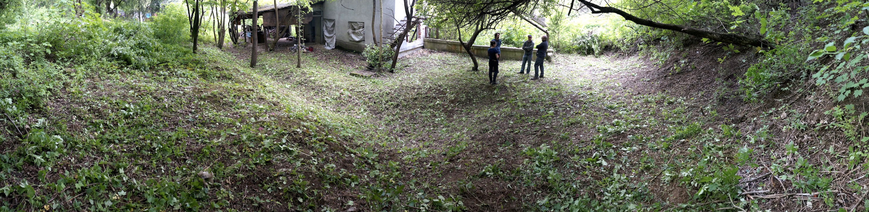
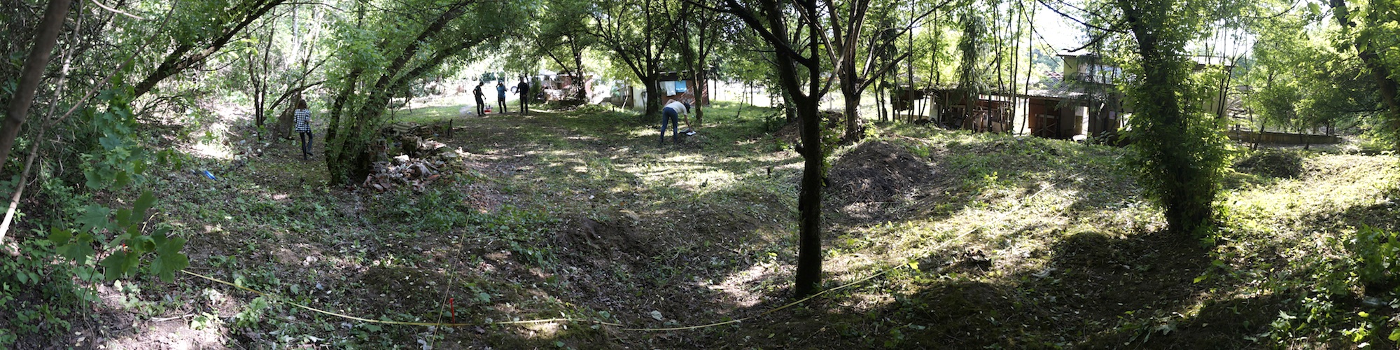
A panoramic view of one end of the complicated north grave site after clearing. Photo © 2019 RJH.
Directional and informational signage, an important goal of this project at both mass grave sites, may be managed separately from other aspects of the project, if the costs associated with rehabilitation of the sites is high enough to delay the larger effort. Both types of signs will be coordinated with the City of Rohatyn so that the materials and designs complement other heritage signs around town, and integrate with overall history and heritage markers developed by the City, its local history museum, and its tourism and public relations functions. Our overall information goals and strategies are described in the Information Points Physical Project and the Information Points Digital Project.
Maintenance
For the time being, ongoing maintenance at the grave sites will continue the current tasks of clearing and cleaning the grounds, as well as occasional light repair of the monuments and seasonal plantings around them, as described above. If/when one or both sites are further developed as memorial grounds, maintenance plans and schedules will be adjusted to provide long-term care of the sites, with the cooperation of the City of Rohatyn.
Project Costs
The total cost of the 2017 mass grave boundaries investigation was US$29,004, including US$24,247 for archaeological research, sites survey, analysis and reporting; US$639 for pre-survey ground preparation (local contract labor); ~US$3200 in local support (interpreting, logistics, etc.); plus US$918 in administrative costs (currency exchange, wire transfer fees, etc.). Of that total cost, US$6177 (21% of the total) was offset by donations from individuals, through Gesher Galicia and via a GoFundMe online campaign created by RJH. The remainder of the cost (US$22,827) was paid through a personal donation from the founders of Rohatyn Jewish Heritage. Not counted in the overall cost is the considerable volunteer time donated by the Lviv Volunteer Center, RJH, the City of Rohatyn and many individuals in pre-survey ground preparation plus other support provided to the archaeology team before and during the site survey.
The cost of the 2019 exploratory design for an expanded, landscaped memorial space at the south mass grave site was US$3080, including US$2800 for architectural concepts and materials specifications and $280 for the geodesic survey. These costs were paid from donations to RJH via Gesher Galicia.
Past costs for site clearing and maintenance have been covered by volunteer effort and small personal donations by Mykhailo Vorobets and Rohatyn Jewish Heritage, through May 2019. Not counted is the cost of hand and motor tools used for clearing actions during past years, shared with other RJH projects in Rohatyn. Beginning in June 2019, that work is covered by local contract labor at a cost of US300 per year paid from donations to RJH through various paths.