![]() Ця сторінка також доступна українською.
Ця сторінка також доступна українською.
Introduction
Mykhailo Vorobets with recovered headstones at the old Jewish cemetery. Photo © Alex Denysenko.
Project plans for rehabilitation and preservation of the old Jewish cemetery in Rohatyn have been in development for over five years, and some ground work has begun during the past three years. This page summarizes a revised and expanded project plan from new research and design work begun in 2019, and details the concepts which drive the plans plus many features of the designs.
The framework for this project plan comes from the website A Guide to Jewish Cemetery Preservation in Western Ukraine (JHG), developed during the 2019-2020 academic year for a Fulbright Program research project led by Marla Raucher Osborn; the JHG site provides guidance, resources, and examples relevant to the Rohatyn project (and others).
Not all facets of the JHG guide are applicable to this project as currently conceived, and not all aspects of cemetery preservation and presentation are addressed yet by the plans. However, the portions which have been developed are in a state suitable for review with city and religious authorities, project contractors, and funding sources. The project has intentionally been broken into phases, several of which can be (or have been) started independently.
In the sections below, a history of the cemetery is presented, followed by an illustrated description of each of the almost dozen components of the project. Project priorities are also defined, identifying opportunities to begin some components while leaving others for future years. Strategies for funding and managing the various components are also highlighted. Over time, we hope to include progress reports and images from project elements as they complete.
All RJH efforts on this project will proceed with the continuing involvement of the Rohatyn city administration and with oversight by the Rabbi of Ivano-Frankivsk.
Read about the history and heritage of Rohatyn’s Jewish cemeteries.
Browse our news articles for coverage of events related to this project.
A Brief History of the Site: Establishment to Current State
A prewar view from the northeast corner of the old cemetery. Source: NYPL.
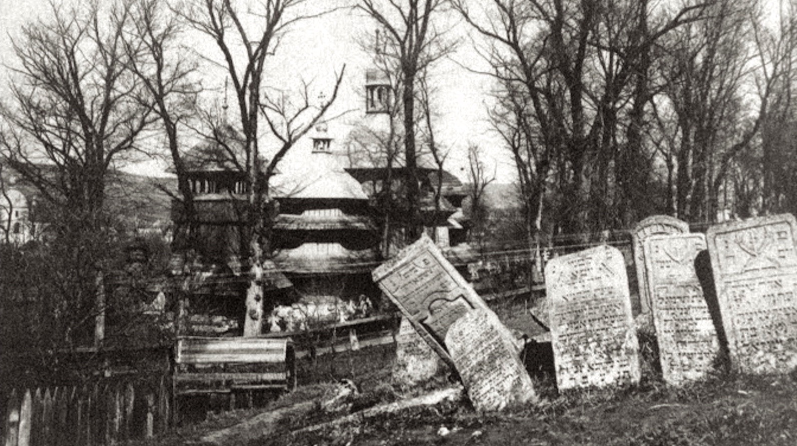
The first or “old” Jewish cemetery of Rohatyn was established on a hilltop outside of the center of the settlement almost four centuries ago and was extended two or more times, serving as a burial site for the Jewish community until shortly before World War II, when it had reached capacity and a second or “new” Jewish cemetery was opened at the northern edge of the city. No cemetery records have survived, but based on Austrian and Polish censuses it is likely that at least 8000 Jews from Rohatyn and nearby villages were interred at the old cemetery during those 300 years of burials. Stone markers with epitaphs and symbolic carving were erected at many of the graves during at least the last two centuries of burials, creating a forest of thousands of erect and toppling stones visible in a few prewar photos and a 1930s film. At that time the cemetery still had almost no residential neighbors; the surrounding landscape was mostly used for raising crops. Even after the old cemetery was closed to new burials, it remained a “house of life” for the Jewish community, a place for prayer and remembrance, and a historical record written in stone of the Jews of Rohatyn.

Three views in the Rohatyn old Jewish cemetery in the 1930s from Fanny Holtzmann’s film. Images © Center for Jewish History.
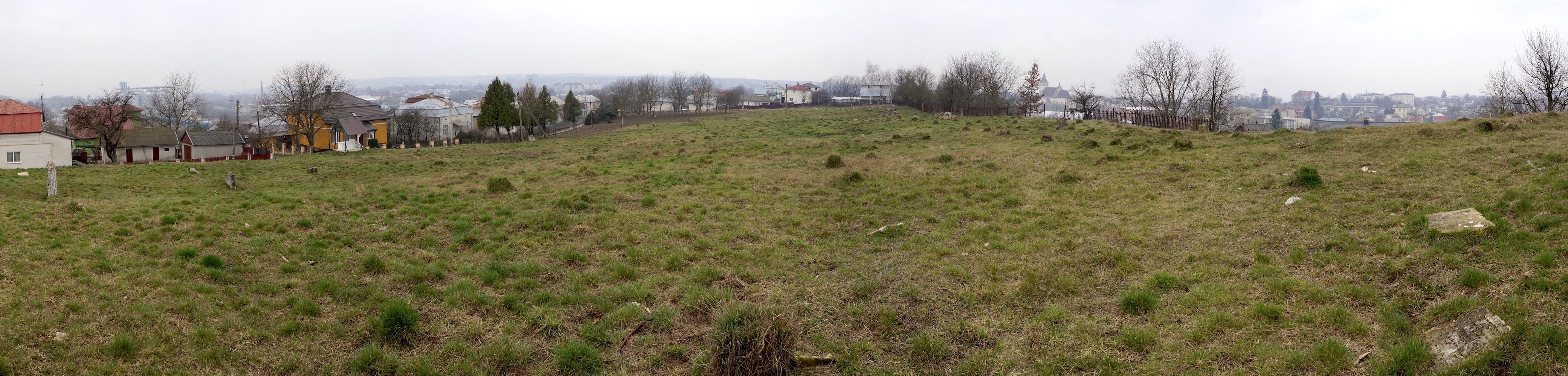
A panorama over the cemetery in spring 2020, viewed from the high eastern end. Image © RJH.
As was true for most Jewish cemeteries in the region, the same actors and actions which destroyed nearly the entire Rohatyn Jewish community during the Holocaust also felled and removed the headstones from the old Jewish cemetery, for reuse as building materials all over town. After the war, the cemetery appeared as a nearly empty hilltop field, with few or no headstones or other signs of its history and purpose. Although the cemetery appearance was altered and its community record erased, it was not a killing site during the wartime occupation and thus does not share the dark history of the Jewish mass graves in Rohatyn.

Two surviving headstones and a 1990s memorial monument, in winter. Photo © RJH.
Some time after the war, a handful of survivors of the Rohatyn Jewish ghetto, together with one or more Ukrainian residents of Rohatyn, gathered 20 to 30 mostly broken Jewish headstones from around town and brought them to the two cemeteries; it is likely that a few stones were reset upright in the old cemetery during these years. In 1998, Jewish survivor and descendant groups erected community memorials and installed boundary fences at both Rohatyn Jewish cemeteries, with support from the city administration. Between 1998 and 2008, a black granite stele was erected near the cemetery east gate to the memory of well-known rabbis buried in the old cemetery by descendant members of their family, and near the end of 2011 an ohel over the graves of three of the most famous Stratyner rabbis of Rohatyn was rebuilt by a Ukrainian Hasidic organization. By this time there were roads and houses on two sides of the burial ground, as the cemetery had been enveloped by the city.

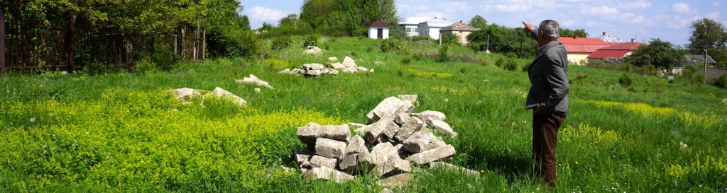
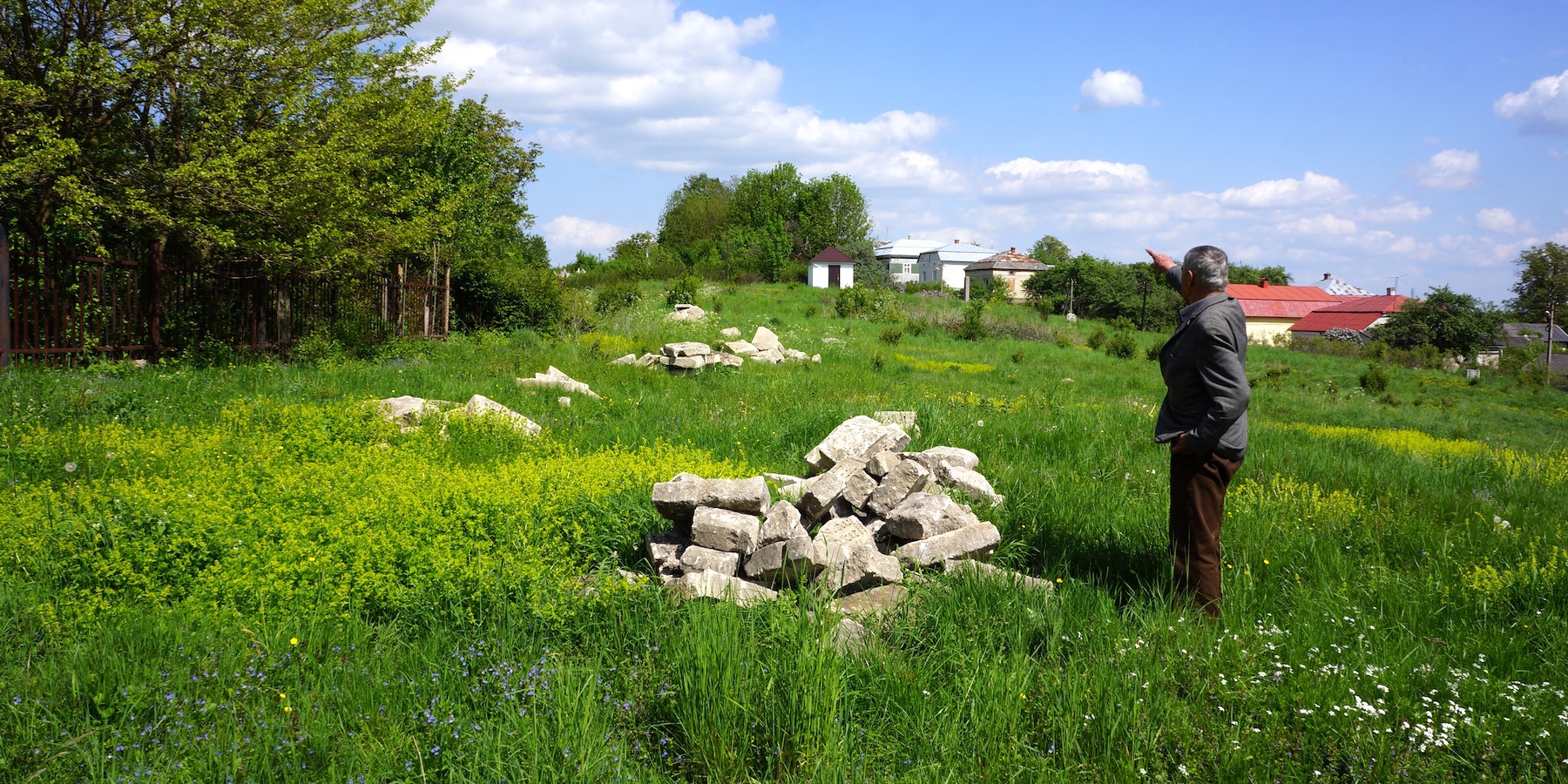
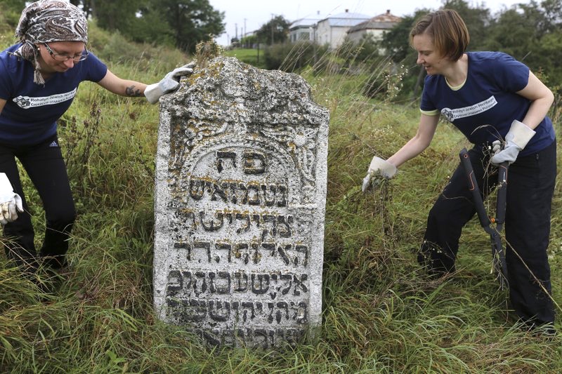
A few of the hundreds of recovered headstones. Photo © RJH.
In Jewish law, a cemetery is a holy place more sacred even than a synagogue, and the care of cemeteries is an essential religious and social responsibility. Care of the old Jewish cemetery in Rohatyn is a primary concern of Rohatyn Jewish Heritage (RJH). Residents of Rohatyn respect all burial sites, but with no living local Jewish community in Rohatyn today, there are few nearby resources available for care on the scale the site needs. The size of the cemetery (roughly one hectare, or about 2.5 acres) means that even simple maintenance, let alone major rehabilitation, scales too large for occasional remedial work.
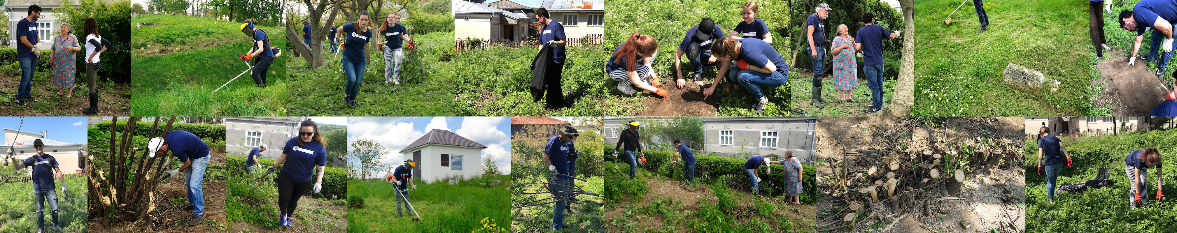
Beginning in 2011 with the start of the RJH project, headstone recovery accelerated thanks to local leadership and support from a retired Rohatyn schoolteacher. Within a few years, hundreds of Jewish headstone fragments had been recovered from streets and buildings of Rohatyn and returned to the old cemetery, and this process will continue, probably for decades. In 2018, work began in earnest to cut and control wild vegetation in the cemetery, and to clean garbage and dumped building materials, with multiple volunteer events of one to five days each, every year. Now the old Jewish cemetery of Rohatyn looks much as it probably did in the early 17th century, before the first burials, though its current appearance obscures its continuing purpose as sacred ground for all Jews, especially those whose families once lived in Rohatyn, now living abroad but retaining a nostalgic connection to the city (and visiting it from time to time).
Project Concepts
Several different perspectives have guided the overall project design and plan, and driven the development of the major project components. These perspectives are synthesized from the JHG guide and its resources; see the project resources page for a list of specific references consulted for the Rohatyn old Jewish cemetery project. The key concepts and themes are distilled as follows:
The essential nature of the place: Despite its current “empty” and plain appearance, the site has been and remains a holy place in Jewish tradition, with many generations of Rohatyn Jewish families buried there; this is the first and foremost essence of the cemetery. With signs and symbols added to the site, we aim to restore recognition and association of the site with the former Jewish community of Rohatyn, and its descendants.
A focus on life: Although the visual appearance of the cemetery was radically altered by the harvesting of matzevot for building materials during and after the war, the cemetery is not known to be a site of human violence during the Holocaust. Remembrance of the Jews killed in Rohatyn or transported to their deaths elsewhere during the occupation is a feature and the primary purpose of the mass grave memorials in town. At this cemetery, we aim to commemorate the hundreds of years of Jewish life in Rohatyn before the war in addition to its cessation during the war. The choices of materials, textures, colors, etc. in the designs reflect a focus on life, both in the past and in the present.
Connecting the cemetery with Rohatyn: New markings, signage, and communication are intended to help reconnect the cemetery to Rohatyn, its residents, and visitors. Fencing and vegetation which serve as boundary markers should remain light and mostly open, so that the cemetery is visible upon approach from the road, the city is visible from vantage points within the cemetery, and the historic connection between the cemetery and the neighborhood is evident. Information signage and QR-code links to online resources aim to show how the Jewish community was integral to the past life of multicultural Rohatyn.
Recovering the value of the culture: The cemetery served as a cultural resource for Rohatyn and visitors in the past, and it can again. Each headstone fragment recovered and returned to the cemetery links personally to an individual; together the many fragments can create a rich picture of the Jewish community, its language and poetry, and its visual arts. The memorial design provides a presentation point for the stones already recovered, and space for several times that number to return in the future. Information signage and QR-code links to online resources give further opportunities for learning and appreciation of the stones.
Modest changes: The planned landscape intervention (additions and modifications), including the memorial feature, is meant to be minimal, identifiable, and reversible, following principles for conservation of art and architectural heritage. No hard features currently at the site will be removed. The plans do not attempt to “restore” the cemetery, but rather to extend its purposes, and hopefully to enhance the site’s ability to serve as a cultural resource. We aim to allow the site and its features to wear and decay slowly. Changes will be modest and with little verticality, so that views across the cemetery are not obstructed and to minimize the “monumentality” of the site.
Project phasing: The design and plan acknowledge the limited resources available to manage, implement, and maintain new changes to the site, and to continue maintenance of existing features. Project features should be low cost and low maintenance, replaceable from local sources and materials, installable with low skills and with a minimum of machinery and specialized tools. New vegetation should be indigenous and selected for the soils and climate, slow growth, low height, easy trimming and maintenance, and long life. The overall project plan decouples the various project aspects/phases from each other, so development can be done incrementally to spread cost and management burdens over a longer time period.
Site Surveys and Research
Several formal and informal surveys of the old Jewish cemetery in Rohatyn have been conducted by Rohatyn Jewish Heritage and others over the past decade, especially since 2017. Data from these surveys is incorporated in the project plans; selected excerpts are summarized here:
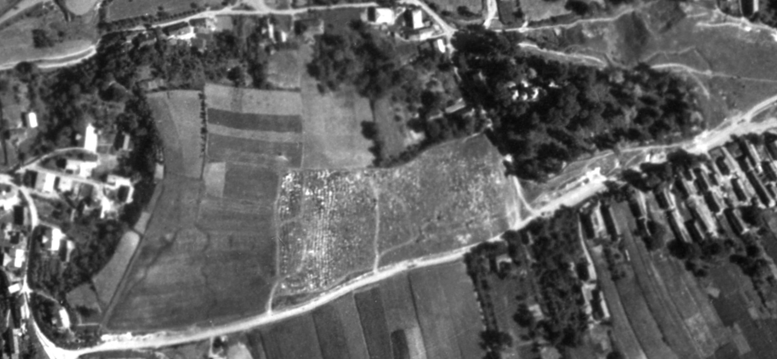
An excerpt from the 1944 Luftwaffe aerial photo.
Image sourced from NARA by Alex Feller.
Desk-based research (RJH): Historical records documenting the first Jewish cemetery of Rohatyn have been found in texts and maps preserved in Ukrainian and Polish archives; many of these are presented on the RJH web pages on the history of Rohatyn’s Jewish community and on historical maps. The maps indicate the size and location of the cemetery relative to other features of the growing city beginning two centuries after the cemetery was established. Of particular value as a historical resource for the project are a Luftwaffe aerial photo taken over Rohatyn in mid-1944 (after the destruction of the Jewish community), and a Soviet topographic map from 1983 which coarsely depicted the ground slope of the cemetery terrain. Because the cemetery perimeter is clearly visible from the air, modern internet maps and satellite images also offer simple methods to approximate the perimeter length and enclosed area, as well as the streets and neighborhood which now envelop the cemetery.

A Soviet topographic map showing the Rohatyn old Jewish cemetery. Image courtesy Routes to Roots Foundation.
Only very limited historical information about Rohatyn’s cemeteries is available in Jewish and other memoirs of life and death in Rohatyn, including the Rohatyn Yizkor Book. More specific information, especially about the Rohatyn cemetery association and the circumstances which led to the closure of the old cemetery and the establishment of a new Jewish cemetery in Rohatyn in the decades before WWII, may come from current research for RJH from DAIFO archival records by a colleague and PhD candidate in history in Berlin.
Recent research for RJH into the current legal/heritage status of the site by LawCraft LLC in Lviv indicated that the old Jewish cemetery is not recorded on the national register of historical places under control of the Ministry of Culture of Ukraine (no heritage sites in Rohatyn are recorded). Likewise the cemetery does not appear on the regional register of architectural monuments of cultural heritage of local significance in the Ivano-Frankivsk oblast (although the south Jewish mass grave memorial and the Holocaust memorial plaque on the former Judenrat building near the city center are each listed). The old Jewish cemetery perimeter is indicated on the Rohatyn city administration general development plan and map (meaning it is subject to city control, plans, and budgets), it is specifically recorded in Rohatyn city files – as “Старий Єврейський цвинтар (поблизу вулиці С. Бандери)” i.e. “Old Jewish Cemetery near S. Bandera Street” – and the cemetery is subject to several permission agreements for care of the site assigned by the Rohatyn raion administration to the Rohatyn city administration and by the city administration to the NGO Rohatyn Jewish Heritage. The current legal recommendation from LawCraft LLC is to pursue greater protection of the site through expanded registration only after rehabilitation work is largely completed by RJH.
Walkover surveys (RJH): RJH has visited, walked, and worked in the old Jewish cemetery of Rohatyn more than 80 times since 2008. A first informal effort at an inventory and photo database of surviving matzevot in the cemetery was begun with other Rohatyn Jewish descendants in spring 2011, though without location references. In the years since, casual and intentional inspection and evaluation of many aspects of the cemetery have been made: boundaries, fences, and gates; terrain profile; fixed objects (matzevot and other man-made features); flora and fauna, both benign and harmful; the neighbors, neighborhood, and environment around the cemetery site; and newly-visible features of the cemetery made visible by frequent vegetation clearing efforts since 2018. Several of the walkover surveys were repeated using instruments in 2017 to 2019 (as described below) to augment the earlier qualitative information with quantitative data.

ESJF manual survey data rendered as a contour map in SketchUp by RJH. Image © RJH.
Land survey for boundary and terrain profile (ESJF): In late 2017, an ESJF engineer conducted a land survey using a total station theodolite to measure the cemetery boundary and terrain profile, with assistance from RJH. The object of this survey was to provide data to support design, planning, and cost estimates for a possible future fence replacement project. Data outputs from the survey included tabulated XYZ point measurements and a DWG file depicting the data in 3D. RJH subsequently imported the data into a CAD system for visualization and as a base layer for the current project design. Although the primary focus of the survey was on the cemetery perimeter for fencing, sufficient measurements were taken of the cemetery interior terrain to make a reasonable calculation of the topographic profile.
Measurements for this survey record the cemetery shape as roughly rectangular with an irregular outline, a total perimeter of about 436 meters (1430 feet), an enclosed area of almost exactly one hectare (about 2.5 acres), and a gradual but variable slope between the highest and lowest corners of about 12.5 meters (an average grade of roughly 8%).
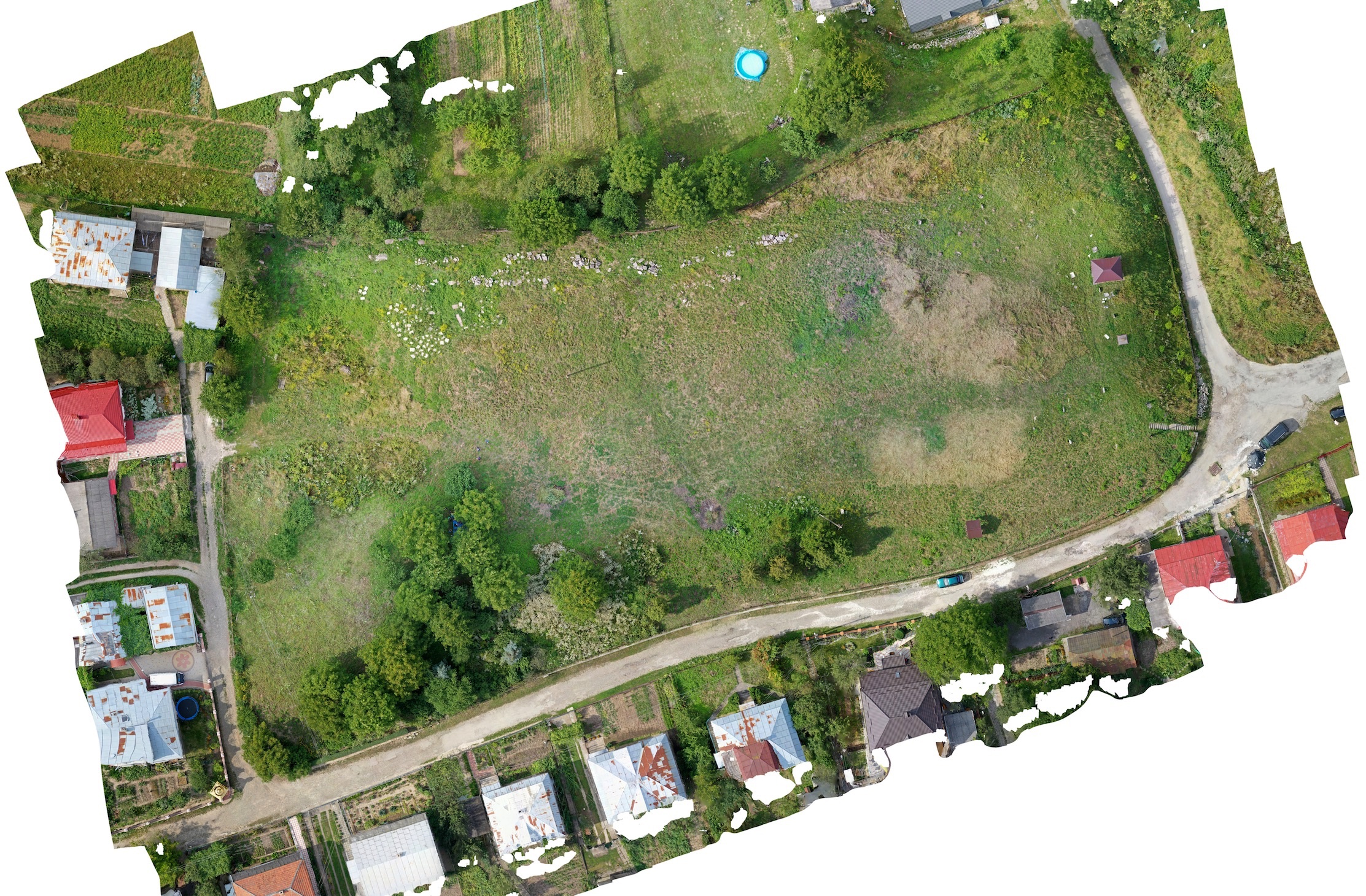
Composite photo of the cemetery from ESJF’s UAV survey.
Image © ESJF.
UAV photogrammetric point cloud boundary and terrain profile (ESJF): In summer 2019, ESJF returned to the old cemetery in Rohatyn for another land survey, this time with an unmanned aerial vehicle (UAV, or drone) taking hundreds of photographs from a low elevation over the site. The goal for this survey was again to measure the cemetery boundary and inner terrain, to include in the database for a pilot documentation project managed by ESJF on Jewish cemeteries across seven countries of east-central and southern Europe. The output from this survey was a large detailed composite photograph and a photogrammetric point cloud which can be used by CAD and other software to create a digital elevation model. For the Rohatyn cemetery rehabilitation project, the composite photo image has been imported into the CAD model as a realistic digital “before” landscape layer on which to build the project plan.
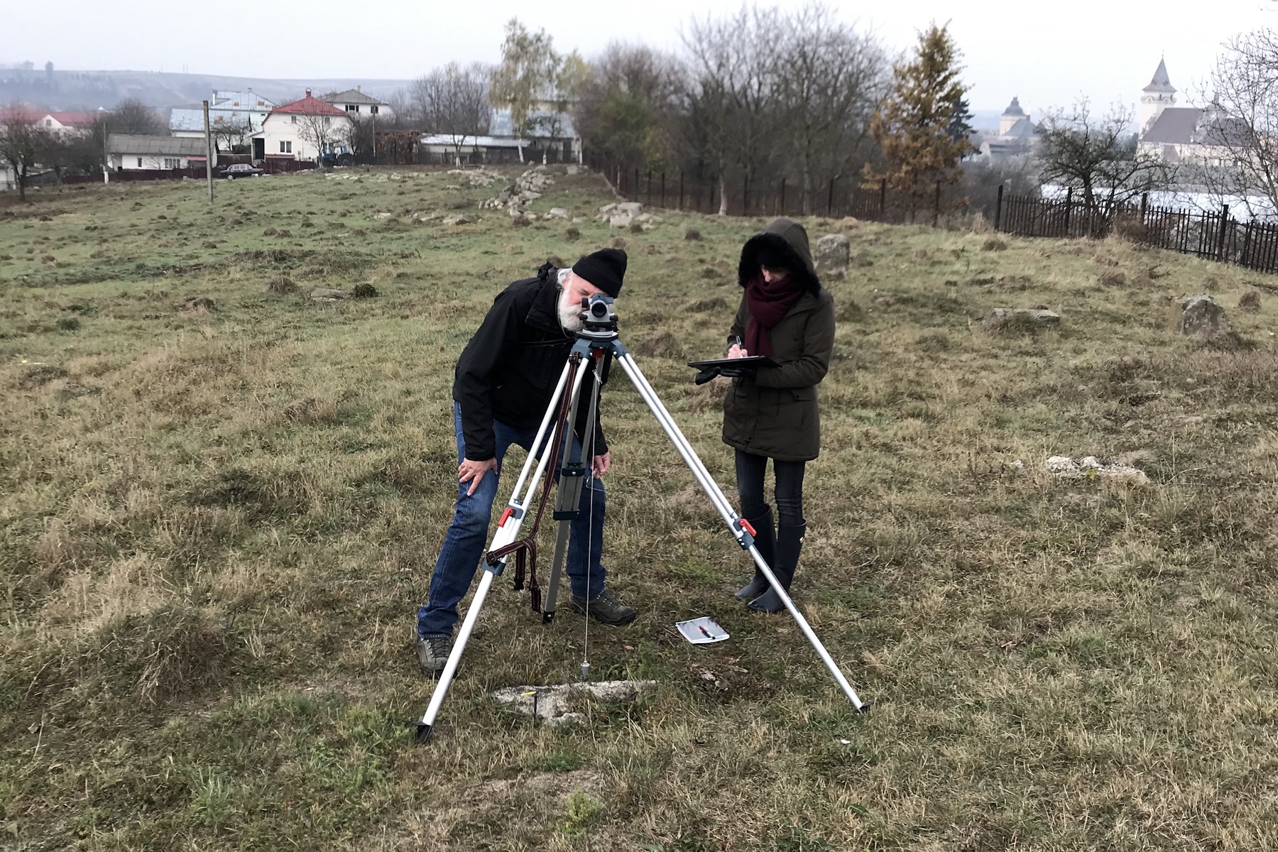
Measuring locations of fixed objects with an optical level. Photo © RJH.
Fixed object geo-location (RJH): In late 2019, RJH tagged and labeled all of the visible fixed objects on the surface of the old Jewish cemetery in Rohatyn, using temporary stakes pushed into the ground. These objects included the handful of surviving upright headstones and prone grave covers, and the two ohels and two memorial stelæ, plus a larger number of stumps of headstones broken off at the ground, as well as power poles, selected trees, and a few embedded concrete objects from postwar misuse of the cemetery. Rough dimensional measurements were also made of each of these nearly 80 objects. An optical level plus three long tape measures were used to accurately locate each of the objects in the horizontal plane with respect to key fence corners which had also been located by ESJF in 2017, so that the two measurement sets could be aligned. This object data (position, size, and orientation) was added as another layer to the CAD model for reference in the new project designs.
Subsurface object geo-location (RJH): A very preliminary and selective survey was conducted by RJH in late 2019 of areas within the cemetery where the stumps of broken headstones may be buried just under the ground surface. Three headstone bases were located this way, in two different sections of the cemetery, and slightly excavated to a depth of less than 10cm to check for residual inscriptions; only one of the three stones retained any recognizable carving. More a proof-of-concept than a survey, the method will be reserved for ground preparation ahead of the headstone memorial construction.
Site Clearing, Cleaning, and Reconditioning
Volunteers together after a long day clearing in the old cemetery.
Photo © RJH.
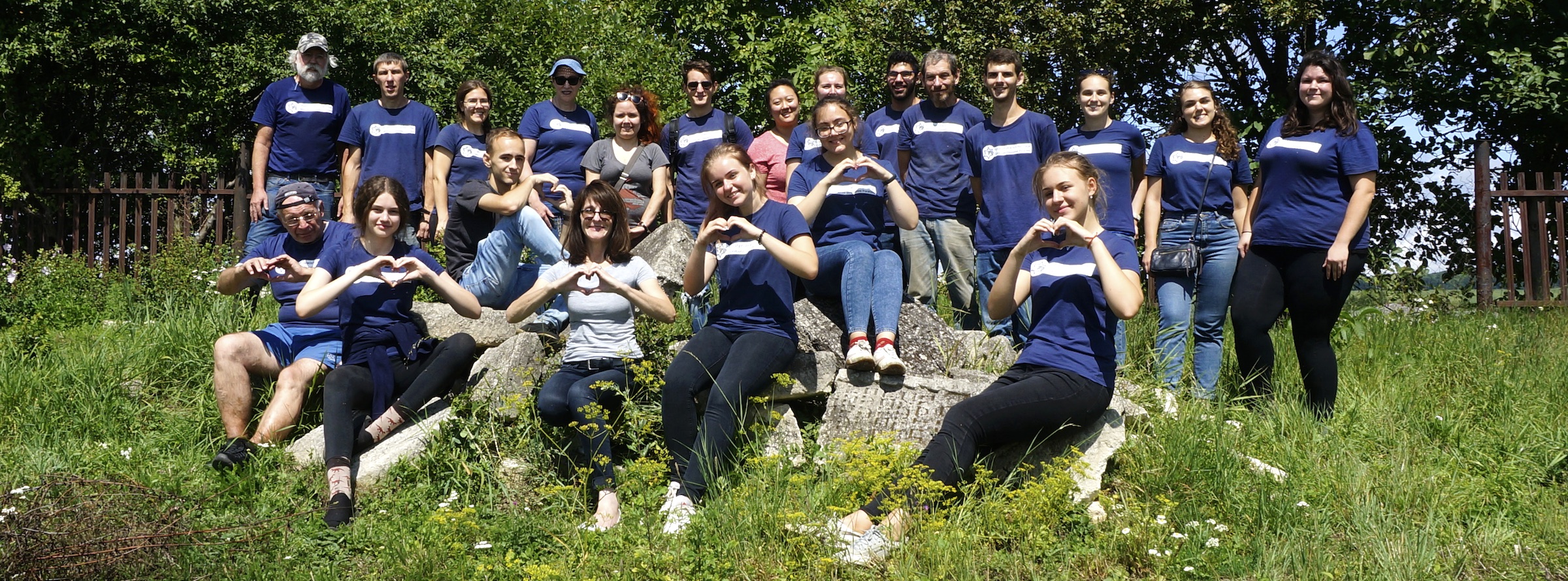
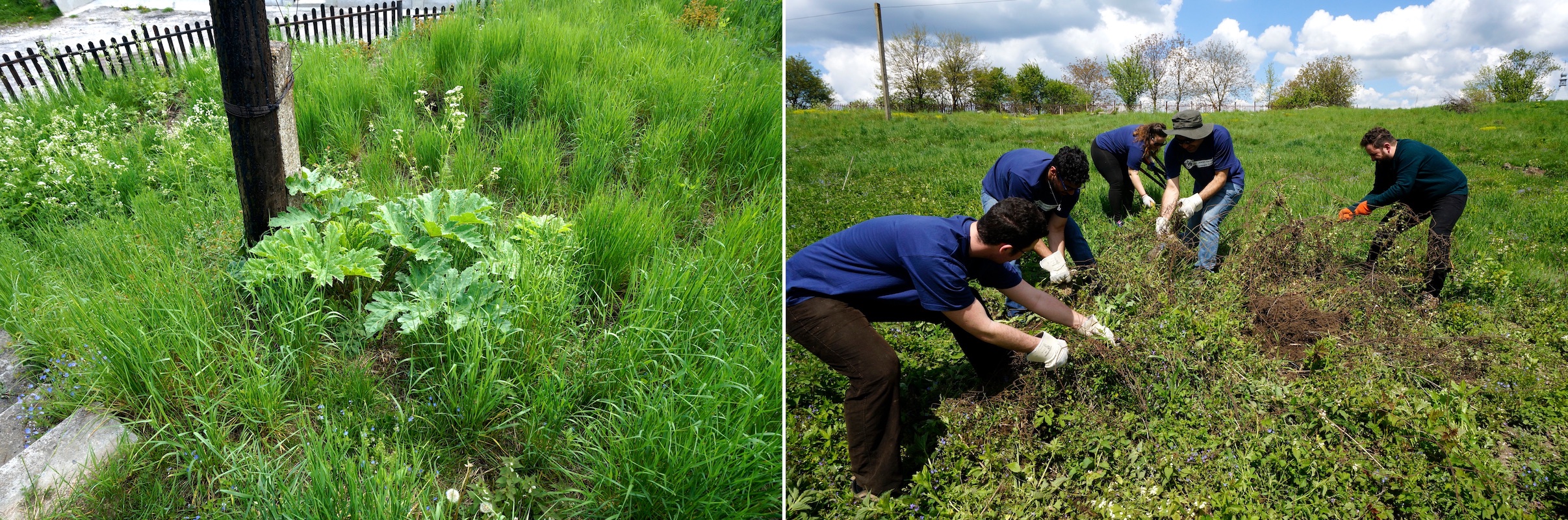
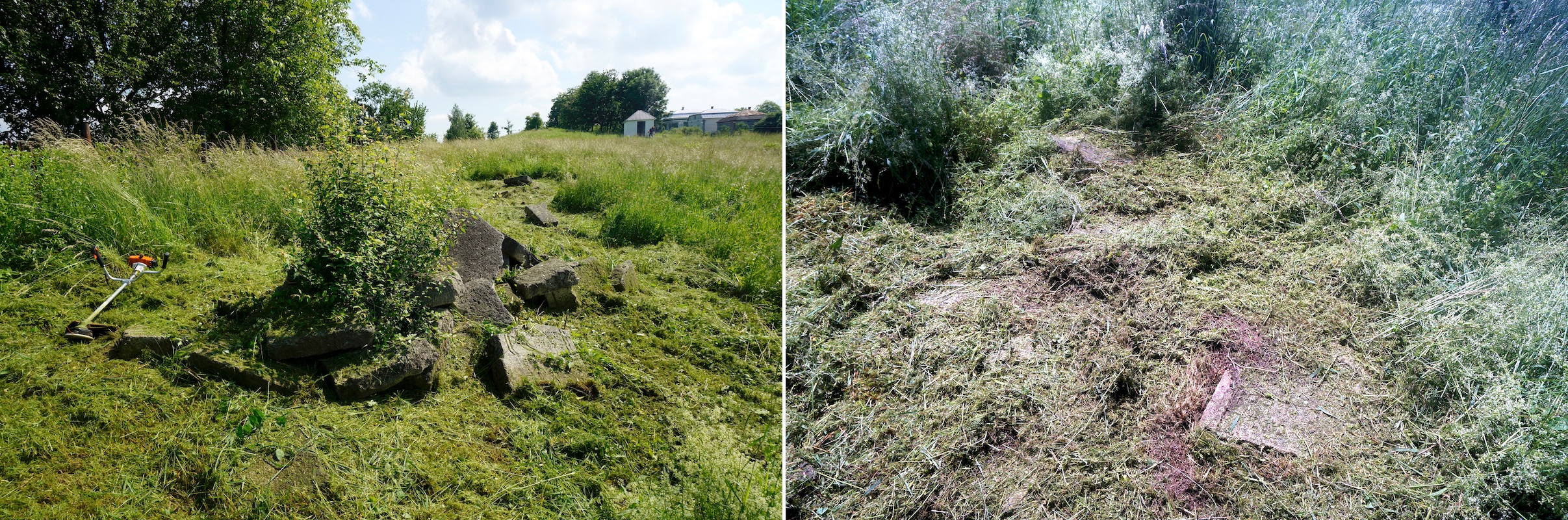
Clearing the Rohatyn old Jewish cemetery of aggressive wild vegetation and accumulated garbage began with a large 5-day volunteer work event in 2018 and has continued since: over 15 days onsite in 2019 with 3 to 25 volunteers per day; more than 30 work days at the two cemeteries in 2020 and early 2021 with just one or two volunteers during the global coronavirus pandemic; in 2021 and 2022 with the three-person staff of Rohatyn Jewish Heritage and a handful of volunteers; transitioning in 2022 and 2023 to local men hired by RJH in Rohatyn, which we hope will be a working strategy for the long term. The goals of this clearing effort have been to:
- cut and remove unwanted opportunistic shrubs and young trees across the site
- cut and thin tall shrubs and overhanging tree branches at the fence lines
- remove dead and low-hanging branches from mature trees within the cemetery
- remove green waste (dumped shrubs, reeds, and trees) from before 2018
- remove garbage (bottles, cans, foil, etc.) from past recreational misuse of the site or waste dumping
- remove dumped construction waste (concrete, metal mesh, wire, etc.)
- remove poisonous heracleum plants and other hazards to workers and visitors from the site
- regularly mow the thick wild grasses to reveal the cemetery land profile and hidden headstones
- trim shrubs and medium-sized trees which may be retained in the project plans
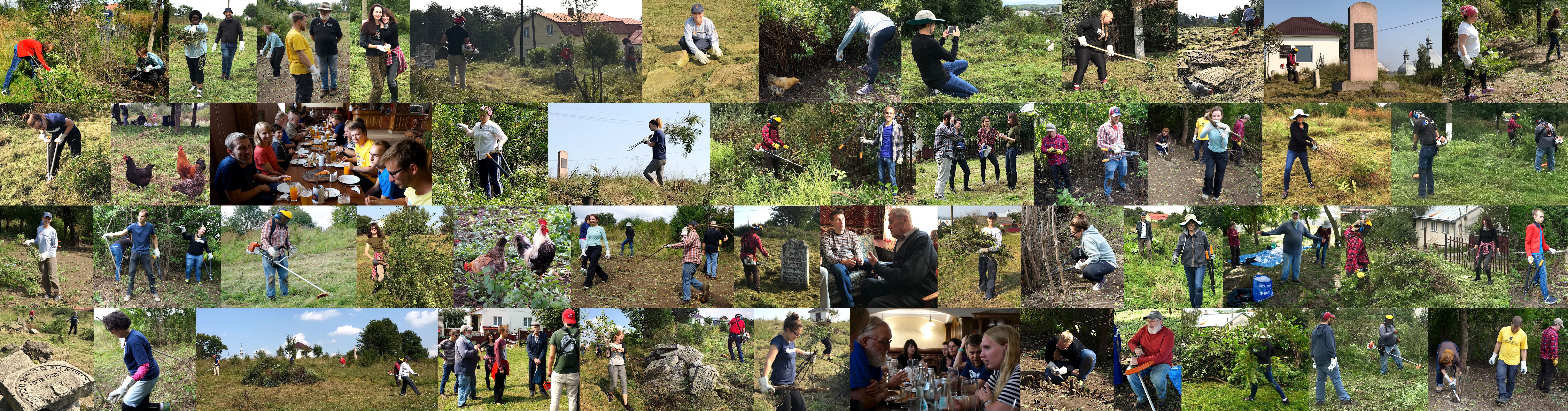
A collage from the week-long volunteer event in 2018. Photos © TMF and RJH.
The activities, costs, and progress of this clearing effort are summarized in RJH annual reports at the end of each year, and link to news stories which show the work in detail; the 2019 report and the 2022 report are typical of the early and recent efforts, respectively.
Images from a volunteer clearing event in 2019. Photos © RJH.
Memorial Design, Development, and Care
The concepts and plans for the overall cemetery rehabilitation project call for retaining all fixed memorial objects in their current locations, including surviving upright headstones, ohels, and memorial stelæ. Similarly, new work will not displace other fixed man-made objects in the cemetery (e.g. electrical power poles and supports) except where those objects no longer serve any community purpose.
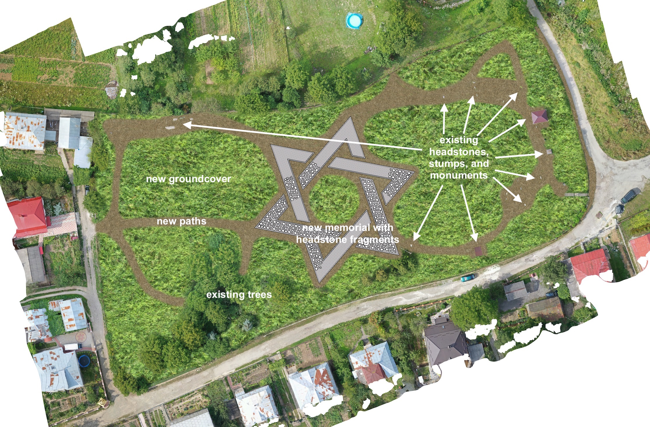
A simulated view of the cemetery and the memorial design from CAD. Image © RJH.
The first key built feature of the rehabilitation project will be a new memorial monument incorporating the recovered Jewish headstones (which are currently being collected in groups as they are returned to an area in the northwestern quadrant of the cemetery). The design for the new memorial serves four purposes:
- to isolate the recovered stone fragments from damp earth, slowing their decay;
- to improve access to each stone fragment for study and contemplation of its unique features;
- to make the placement of each stone fragment provisional, so that fragments originally from a single stone but found in separate locations may be brought together; and
- to amplify the Jewish identity of the site, while maintaining a low visual profile so visitors can view the entire space from any position within the cemetery.
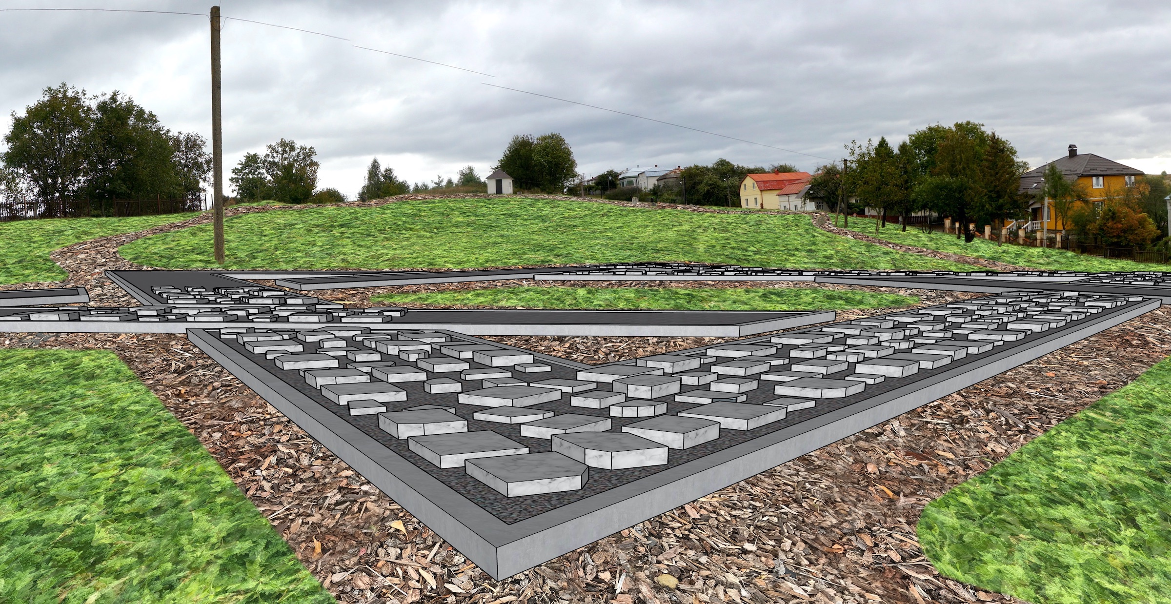
A simulated view of the memorial design from the perspective of a visitor. Image © RJH.
The memorial will be created in the shape of a Star of David (Magen David, also called a Shield of David), a hexagram ornament commonly associated with Judaism (although its use has never been limited to only Jewish purposes). The star will be built nearly horizontal, placed on and projecting above the surface of the cemetery to a short height, typically 20-25cm (8 to 10 inches), and generally following the contour of the landscape where it is installed. The star will extend to a diameter of about 50m, fitting well within the width of the cemetery and centered approximately in the middle of the site, adjusted to avoid interfering with other existing fixed objects. The overlapping outline of the star will be cut into six segments, without altering the bold outline of the symbol, to provide walking paths between and around the segments so that visitors can reach all sides of each segment they wish to closely examine.
The perimeter of each memorial segment will be assembled from lengths of precast concrete road curbing, embedded slightly into the ground surface for stability and set with a small space between each length of curbing to promote drainage of rainfall and snowmelt. Within each segment, existing grass will be scraped to earth level, then a layer of geomembrane (HDPE, PVC, EPDM, or other thermoplastic sheet) will be laid to prevent wicking of water up from the soil; then a thin layer of sand (or a geotextile) will be applied to protect the membrane. On top of the protective layer, a thick layer of medium (20~40mm) or large (40~70mm) mixed grey crushed rock will fill the space within the curbing perimeter, providing a low-contact surface on which to place the headstone fragments.
The size of the memorial ensures space for ongoing recovery and presentation of headstone fragments. At the proposed 3.5m star segment width, the total projected surface area of the star is about 700m². For comparison, an estimate of the required display area for all headstone fragments recovered in Rohatyn during the first decade of work is 170m² (with typical current fragment dimensions and a moderately tight pack which averages 3 stones per square meter); thus the design allows for roughly four times the current number of recovered stones, or even more if the stones are packed closer together.
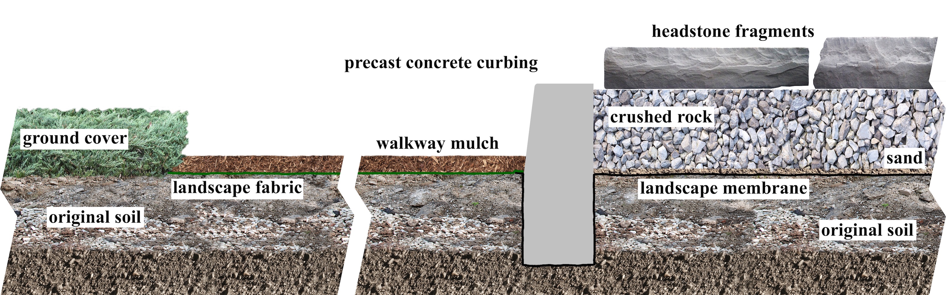
A proposed cross section of the memorial, perimeter border, and adjacent walking path. Image © RJH.
The memorial design minimizes excavation of the cemetery surface, limited to shallow depths already accepted by Rabbi Kolesnyk of Ivano-Frankivsk, and only in the narrow perimeter of the segments; all other materials in the design are placed on or above the current soil surface. The design can be laid out on site with simple survey equipment and constructed with unskilled labor (e.g. volunteers) and without complex tools. Although not currently part of the plan, it would also be possible to stage the assembly by segments to spread the material costs and labor out over time. Should an alternative memorial design be proposed in future years, either to accommodate still more recovered headstones or for another reason, the star could be dismantled and removed without complicated equipment or permanent damage to the site, and most of the materials could be recycled for other building projects.
Because of the chosen materials and the simplicity of the assembly, the design is expected to weather slowly and well, although the built features should be inspected occasionally during the first few years to monitor how well the assembly sheds water, and whether there is any significant intrusion of grasses, weeds, or mole and ant hills.
A simulated internet map aerial view of the cemetery with the new memorial design. Image © RJH.
In addition to providing a platform on which to present the extent and variety of individual grave markers within the cemetery, and signifying in low relief the Jewish history of the space visible from all locations at the site, the design also serves an additional identification purpose for remote/virtual visitors. With the use of contrasting colors for the cemetery paths (made from finer crushed rock, perhaps of red sandstone or black granite) and landscape vegetation (primarily in shades of green and yellow), the star segments in shades of grey (both crushed rock and the limestone of the vast majority of recovered headstones) will stand out visually even from large distances. Similarly, the contrasting shapes of these areas (the organic curves of the paths and planted areas vs. the straight and angular star segments) will sharpen the visual differences of the different materials. Together these characteristics mean that the memorial will be visibly distinct in aerial imagery, easily interpreted by anyone who recognizes the Star of David as a common Jewish symbol. New captures of aerial images for internet mapping databases after the completion of the memorial will then present this image to worldwide users of the platforms, just as similar designs are visible at memorial sites in Rhodes, Greece (about 1/3 the proposed size of the Rohatyn design), and in Denver, Colorado (about 3 times the size).
Depending on the height of border curbing chosen (and the resulting depth of crushed rock), estimates of the total materials cost for the complete memorial range US$6,000 to US$18,000, using sources in the Ivano-Frankivsk or Lviv oblast (to minimize transport costs of more than 300 tons of materials). Labor and other costs will be estimated when the preferred materials can be selected by in-region inspection.
Landscape Planning, Development, and Care
Two ongoing landscape issues in the cemetery: poisonous hogweed, and entangled wire cloth. Photos © RJH.
Sequential phasing of the overall cemetery rehabilitation project calls for starting landscape design and development after the new memorial is built in the cemetery and the loose recovered headstone fragments have been installed in place. Planning for the landscaping portion of the overall project will strive to place paths around the new memorial so that visitors can comfortably view and appreciate the recovered stones, and walk easily to and from the entrances, the few standing headstones, the upright memorials and ohels, the new information signs, and the several viewpoints from the cemetery which overlook the city of Rohatyn and the hills beyond. A preliminary estimate of the cemetery area allocated to roughly one kilometer of paths is about 15% of the total.
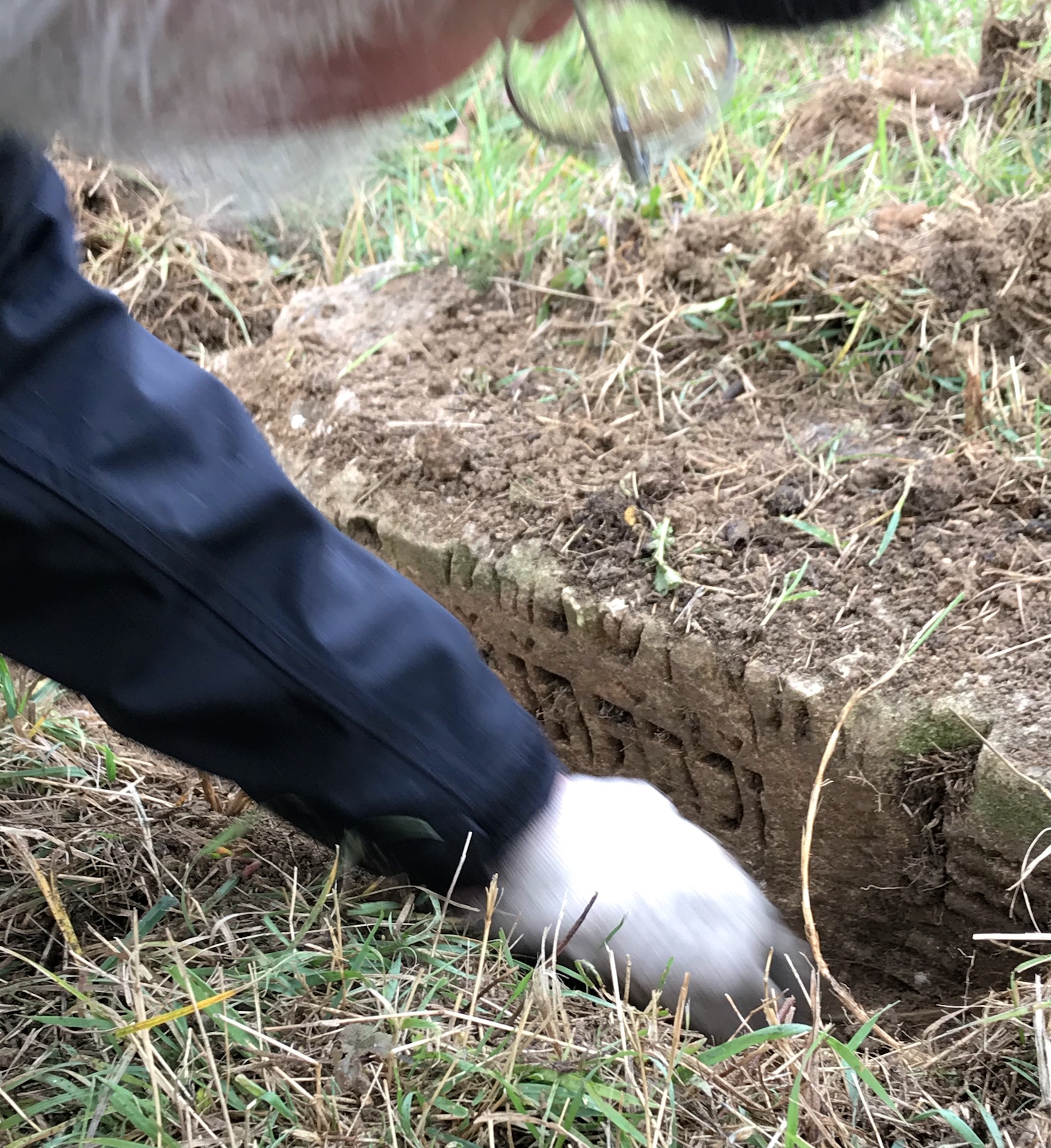
A buried headstone stump with a legible fragmentary inscription. Photo © RJH.
Until the new memorial is implemented, landscape planning will focus on progressive site clearing and cleaning activities (see above) especially including the control of poisonous plants and the removal of hard debris and waste building materials. As noted, the landscape concept includes retaining the larger trees plus some boundary hedges and flowering shrubs both in the short and long term. Desk-based and field research will include identifying a few slow-growing and frost-tolerant native ground cover plant species for planting in areas around and between the new memorial, paths, standing headstones, etc. As for the new memorial, the locations of residual embedded stumps of old headstones which lack any identifying inscription or carving will be noted, but in most cases the stones will not be further revealed and will likely be covered by new vegetation. Stones with legible inscriptions will be revealed by shallow excavation and documented, then either left revealed (reserved from new planting, with landscape fabric and inorganic ground cover) or covered again, on a case by case basis.
Following research and the completion of the new memorial, the fast-growing wild grasses and shrubs will be gradually replaced with new plantings of the identified native ground cover species. At this time, the concrete stairs at the east entrance to the cemetery will also be due for reconditioning or replacement.
Stone Conservation, Documentation, and Care
Recovered headstone fragments piled in the old cemetery. Photos © RJH.
A priority for slowing the ongoing decay of the recovered headstone fragments is to separate them from direct contact with the cemetery ground surface, and the seasonal wicking of ground water into the stones. The design of the new memorial will provide some protection for the stones through the barrier layer of heavy rubber sheet and the upper layer of large-sized gravel or crushed rock (which minimizes contact area for transfer and increases the water path length). Once the recovered fragments are moved to the new memorial, a treatment plan for drying, cleaning, and sealing the headstones (both recovered loose fragments and the few standing stones) will begin. This plan will be evaluated by expert stone conservators at the Lviv Polytechnic University or a hired professional, and conducted with training and guidance from experienced conservators and/or students.
As part of the conservation effort, each stone will be numbered and photographed and/or scanned, for future description, transcription, and translation. Data from this documentation will be entered in a public-accessible database for searching and viewing on this or a related website. Interpretation of the epitaphs (and especially any names found) will be made available for review and revision by recognized specialists, perhaps including the Jewish Galicia and Bukovina (JGB) organization.
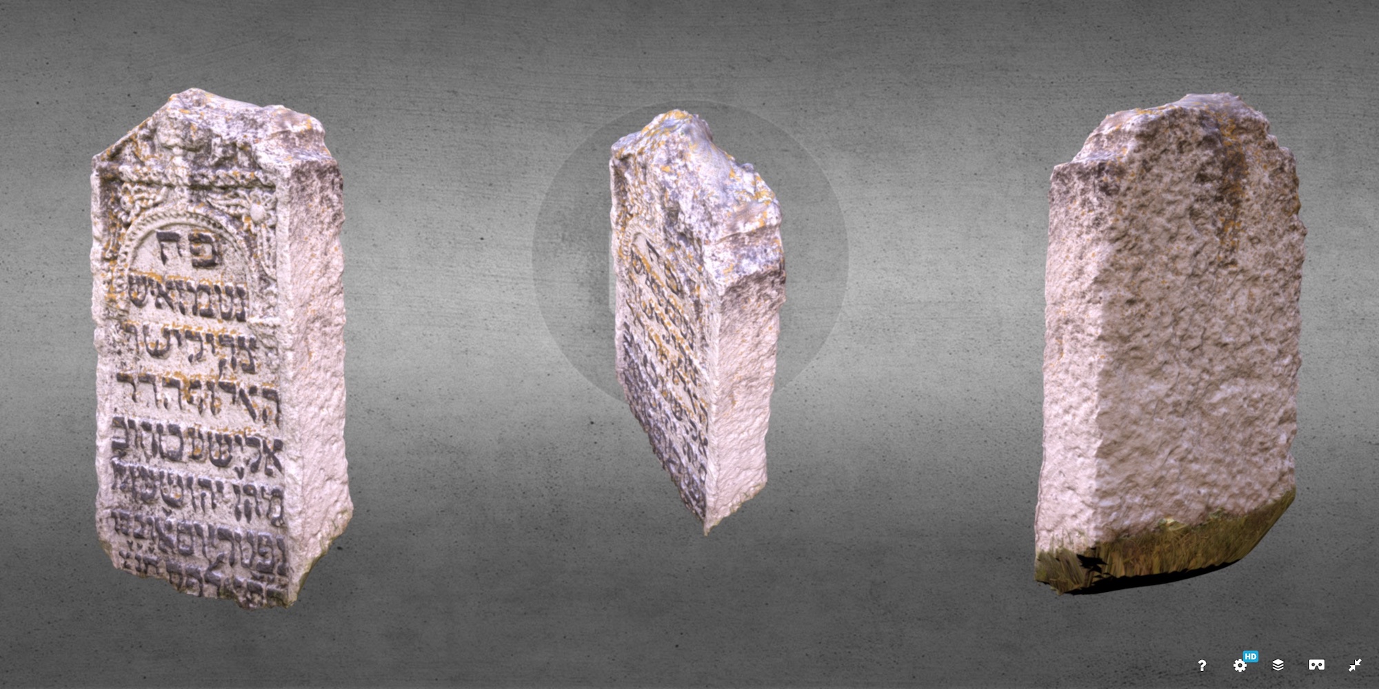
An interactive 3D display of a standing headstone in the old cemetery. Image © Centre for Archaeology at Staffordshire University.
Photographing and/or scanning the headstones creates an opportunity to document them more fully, including the creation of 3D digital images through close-range photogrammetry as was trialed by researchers from Staffordshire University’s Centre of Archaeology in 2017. Specific plans to capture a more detailed record of the current state of each stone will be considered once the stones are in place on the new memorial.
Other existing stone monuments erected in the old cemetery beginning in 1998 are currently in good condition, and should only require monitoring for cleaning, maintenance, and small repairs for perhaps another decade or more. Maintenance of the two ohels in the cemetery will continue to be performed by the organization which erected them, Oholei Tzadikim, and are not included in this project.
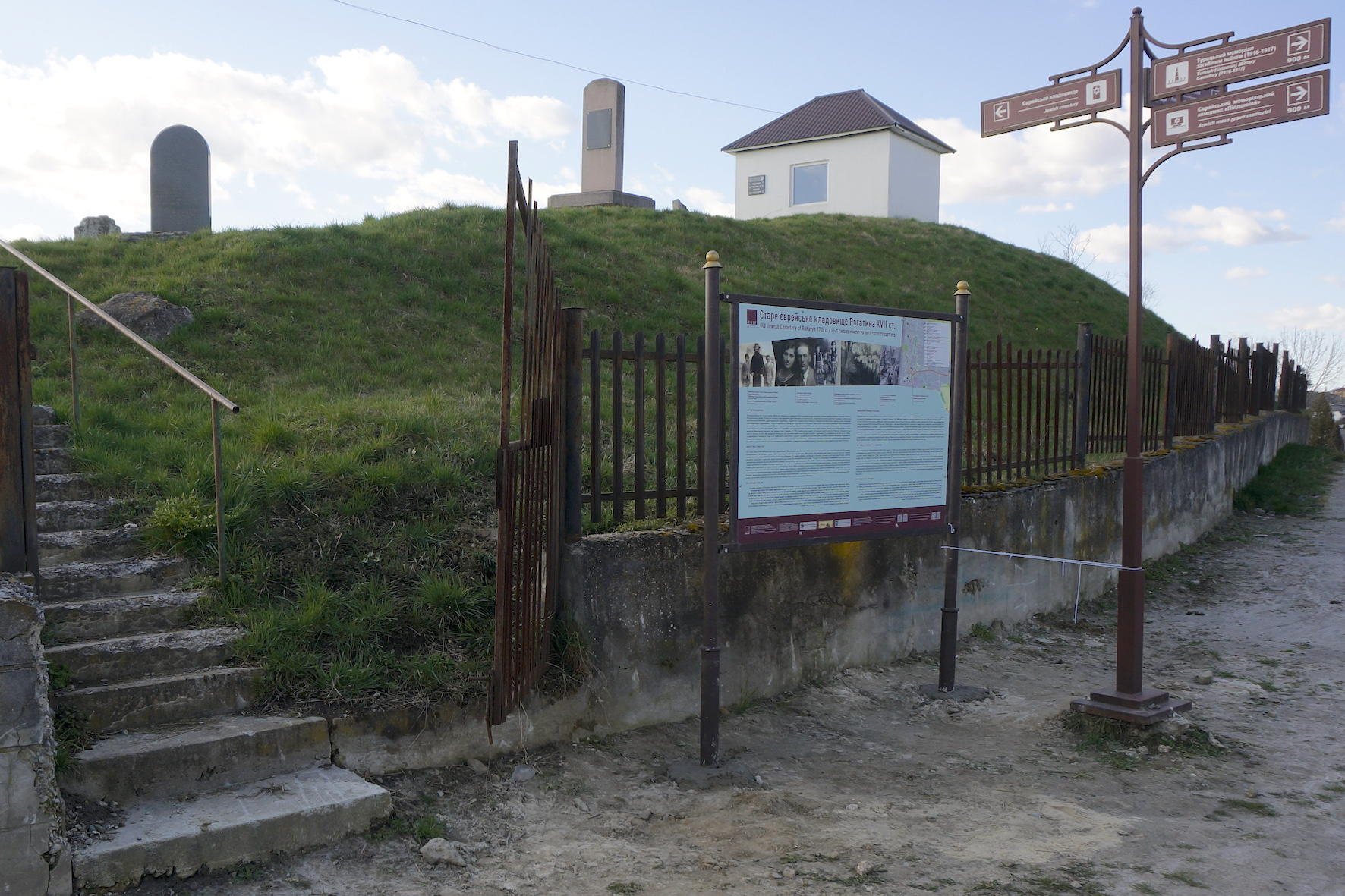
Directional and Information Signage
The old Jewish cemetery rehabilitation project includes sign installations to direct visitors to the site, to identify the site and its purpose, and to inform visitors about the history of the cemetery, about the Jewish community of Rohatyn, and about the valuable cultural resource carved into the surviving headstones.
There are international, European, and Ukrainian national standards governing road signs (see the project resources page), but few of those requirements apply to heritage sites, and the standards conflict with each other in some key areas. Thus for the design and implementation of the three primary classes of physical signs for this project, a number of related heritage signs in Ukraine and elsewhere in Europe (also shown on the resources page) were used as reference to complement the standards. Compatibility with signage for other heritage sites in Rohatyn is essential to comprehension and utility of these project signs for the Jewish sites, and to their acceptance in the city for the long term. Sample designs shown here are conceptual, and subject to review and coordination with the Rohatyn city administration for style, content, materials, fabrication services, and installation methods and locations.
A proposed directional road sign for the old cemetery. Image © RJH.
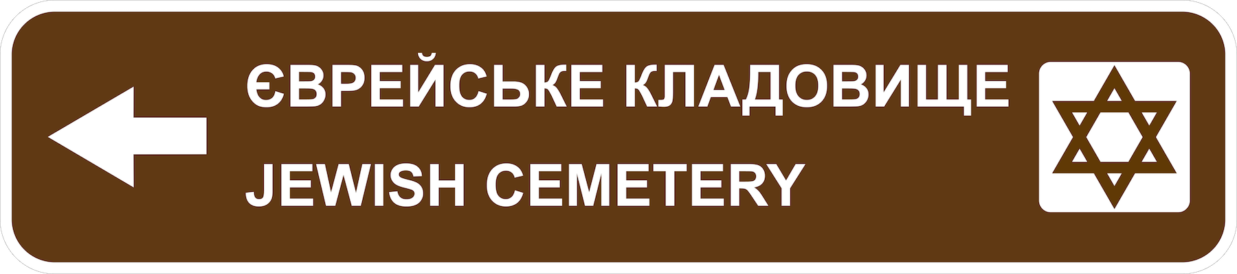
Directional road signs: The old Jewish cemetery in Rohatyn does not front on any major roads, and access by car requires transit on two to four minor roads, depending on how one chooses to approach. Clear guidance to the site requires coordinated signs with arrows at several intersections to indicate turn directions.
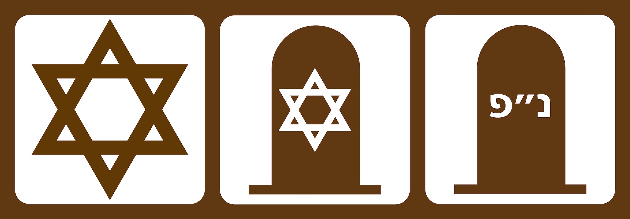
Alternative symbols denoting the Jewish cemetery
as a heritage site. Image © RJH.
A sample bilingual road sign directing visitors to the cemetery is shown here, along with some alternative symbols to indicate the type of place. Priority for the design elements of the sign (shape, size, corner radii, text typeface, text capitalization, arrow shape, etc.) is given to the Ukrainian national standard. Other design elements (e.g. colors) are taken from examples in both Ukraine and larger Europe. Some design elements (symbols) are devised for this project based on approaches used for similar places elsewhere. The design is intended to enable visual and practical compatibility with related directional road signs for other heritage sites (Christian cemeteries, WWI and WWII memorials and graveyards, churches, etc.) and for key civic and recreation areas (city hall, parks, etc.).

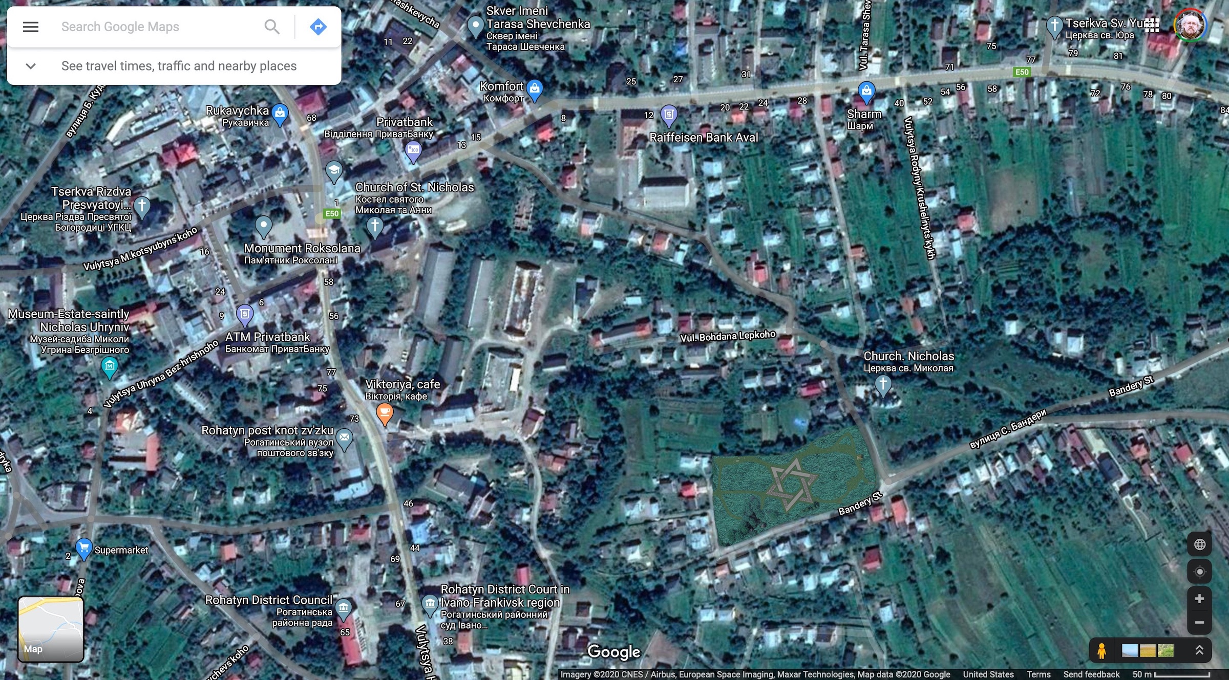
A map of Rohatyn showing proposed locations of directional road signs (blue arrows) to the old cemetery (blue star). Map image © OSM contributors.
A schematic map of Rohatyn is also shown here, indicating suggested placement of directional road signs. At most of these locations, two signs should be installed back to back or on opposite sides of the road to direct drivers approaching from each direction.
The sign materials and installation hardware are not specified, and should be defined by the Rohatyn city and raion administrations to be durable and consistent with other road signs in the area. Based on existing road signs, we assume the new sign would be painted metal sheet, attached with steel brackets to existing or new metal poles or other structures.
Directional pedestrian signs: At the beginning of 2021, the Rohatyn Opillya Museum of regional history led a project for the City of Rohatyn to design and install signs on city streets and at the town square directing pedestrians to sites of local heritage, including three of the Jewish burial sites: the old cemetery and both Holocaust mass grave sites. In addition, a large tourist map installed at Roksolana Square in the city center shows all four burial sites (including the new Jewish cemetery). A tourist brochure available at the Opillya Museum and at City Hall duplicates the heritage features map and can guide visitors to all of the sites as well as parks, bus stations, and other helpful city services.
A few of the directional signs pointing to heritage sites around Rohatyn. Photos © RJH.
A proposed identification sign for the old cemetery.
Image © RJH.
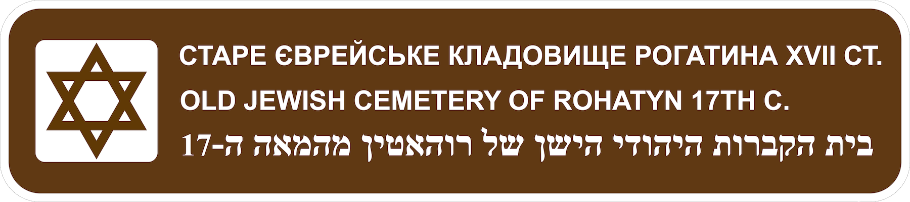
Identification signs: Absent national or European standards for marking heritage sites, the proposal shown here adapts the design rules and examples for directional road signs to serve for site identification as well, in order to clearly relate the journey to the destination (e.g., in the terms used for the place and in the symbol which represents it). Compared to the directional signs, the identification signs provide more information (the century in which the cemetery was established, and the designation “old” to hint there is another Jewish cemetery in town), and adds a third language (Hebrew).
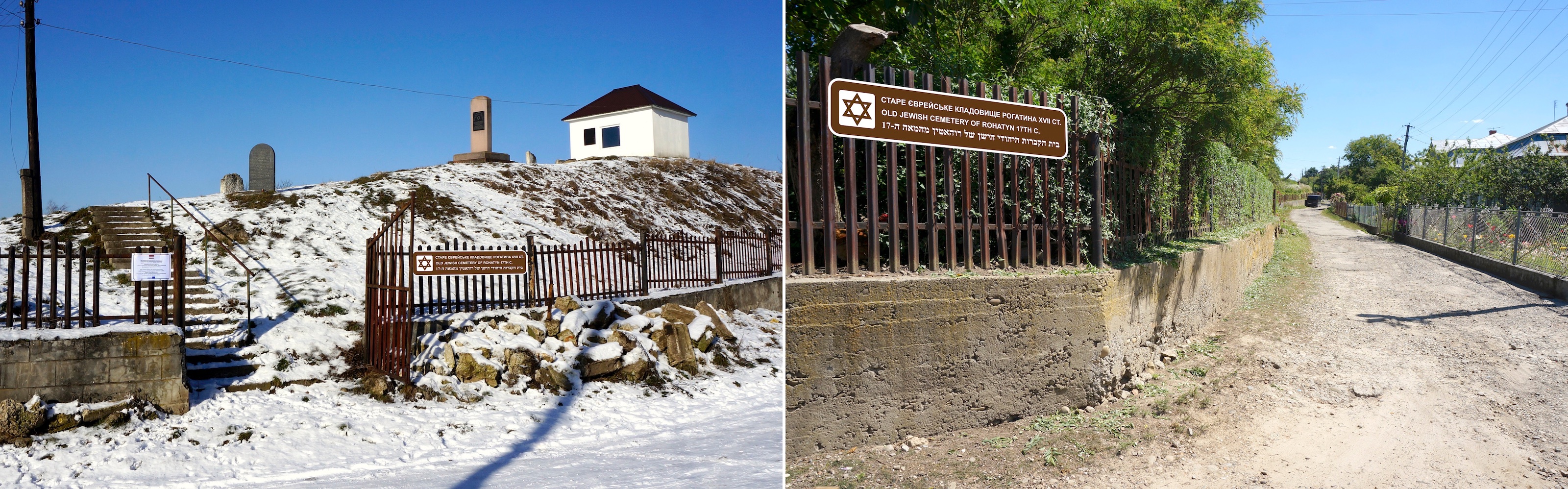
Sign attachment options at the east and west ends of the cemetery. Images © RJH.
The identification signs should be fabricated of the same materials as the directional signs, for visual compatibility and durability. The primary sign would be attached with tamper-resistant brackets to the cemetery fence, or to two or three poles bolted to the retaining wall, just to the right of the upper (east) gate opening, in clear view of drivers and pedestrians approaching from the north or east. The second sign would be similarly attached to the fence at the southwest corner of the cemetery, clearly visible to pedestrians approaching on trails from the west. The signs illustrated in the mock-up images here are scaled to a size of 180cm by 40cm, but other sizes are possible if the city administration adopts a different standard.
Informational sign – cemetery/community: One of the memorial stelæ at the top of the cemetery includes very brief remarks about the Jews of Rohatyn (the other is a family memorial in Hebrew only), and the closed ohel nearby identifies by name the three religious leaders buried within (also in Hebrew only). Otherwise there is no historical information available at the cemetery about the site or the Jewish community which established and used it. Visitors to Rohatyn who are interested in the local heritage may learn more about the town’s Jewish history at the local history museum “Opillya” (400m away) and of course “virtually” on this website, but only some of the people who find and enter the old cemetery will use those resources, and there is no better place to explain the cemetery than at the site itself.
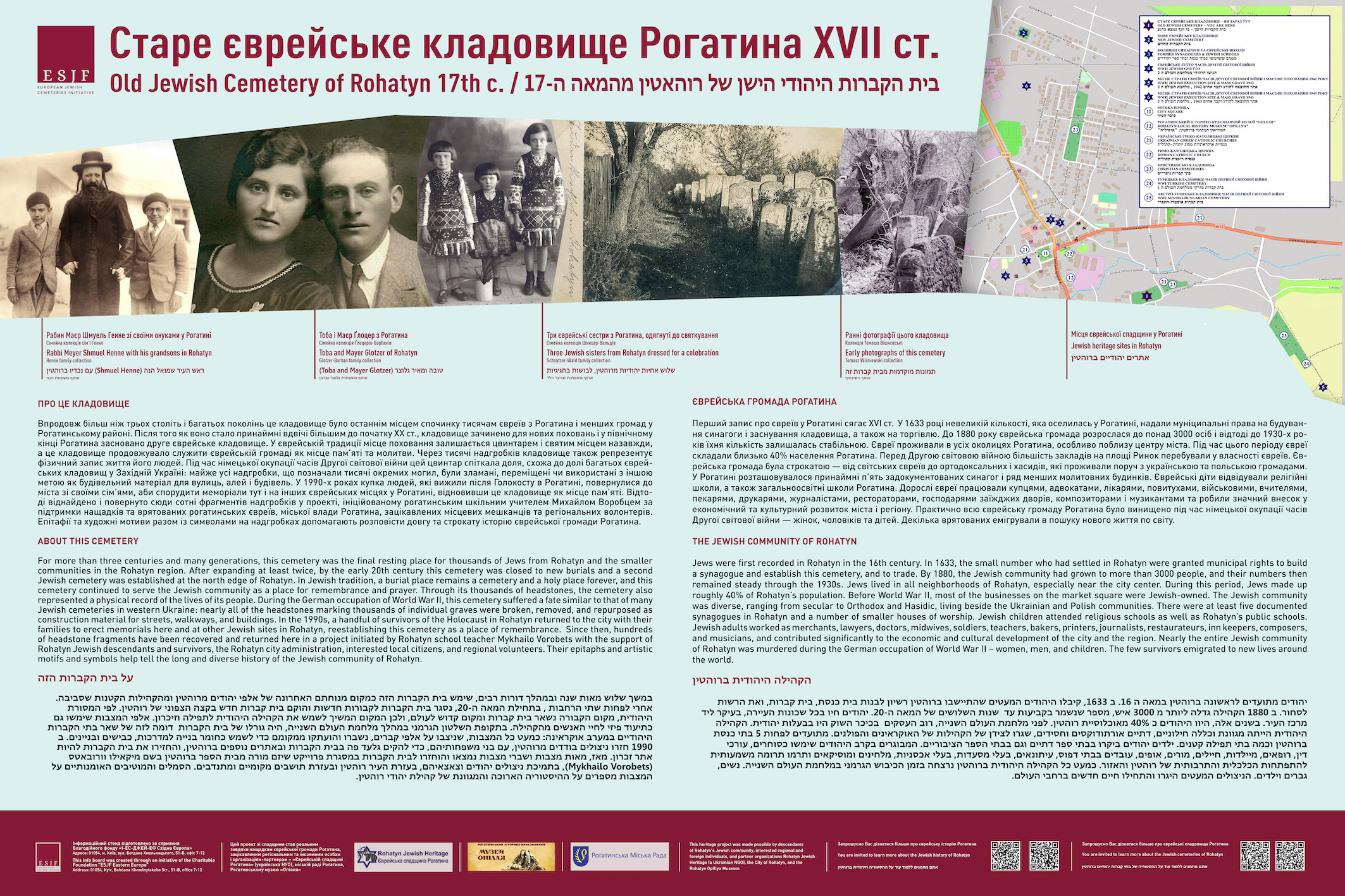
The design for the new cemetery information sign. Image source ESJF and RJH.
In spring of 2023 a medium-sized information sign was installed outside the cemetery perimeter, adjacent to the east gate, to encourage visitors to enter. The sign is sized to present enough information for visitors to help them understand the site in historical and geographical context. The sign panel is nominally 1.5m wide by 1.0m high (about 60in. by 40in.) with these features:
- three languages: Ukrainian (primary), English, Hebrew
- a history of the Rohatyn Jewish community
- photos of Rohatyn Jews in the interwar period
- a history of the cemetery
- photos of the cemetery from WWI and the interwar period
- QR code links to history and heritage pages on this website
- acknowledgment to descendants and supporters of the project
- a map of Jewish and other heritage sites in Rohatyn, with a key
- plastic printed film laminated to a formed steel sheet and supported by two steel poles embedded in concrete at the base
The design of the information sign is shown here at reduced resolution (due to file size); the full printed image is created at 300dpi.
The sign as installed in front of the old Jewish cemetery in 2023. Photo © RJH.
RJH researched and wrote historical text in English for the sign, and created the map of Rohatyn Jewish heritage sites. Translations were contributed by long-time supporters Natalia Kurishko (to Ukrainian) and Rohatyn descendant Ruthy Erez (to Hebrew); historical photographs were provided by several Rohatyn Jewish descendants and by historical image collectors. For the design and fabrication of the sign, RJH partnered with ESJF European Jewish Cemeteries Initiative (Alexandra Fishel, Alex Bessarab, Philip Carmel) so that the sign met the high standards which they have been applying at many installations in Ukraine and other countries where ESJF has fenced Jewish cemeteries. The original sign concept and installation location were reviewed and approved by the Rohatyn city administration prior to fabrication, and we thank both the Rohatyn City administration and the local history museum «Opillya» for their support.
Informational sign – headstones/culture: A second information sign is under consideration for installation in the cemetery, to provide resources in three languages about the cultural significance of the epitaphs and symbolism carved into the headstones, and about the ongoing Jewish headstone recovery project in Rohatyn. Examples of artwork and epitaphs from recovered headstones would be included to illustrate the variety of symbols and stonework. Further concepts, detailed design, and installation planning for this sign will be pursued after the central memorial monument which presents the recovered fragments has been created. Materials, fabrication, and installation details are expected to be similar to the history information sign, incorporating lessons learned from that first example. One possibility is to attach this headstones information sign to the reverse side of the cemetery/community sign, and the overall design will be detailed to allow for this possibility.
Cemetery feature signs: To encourage visitors to walk the paths of the cemetery and to view the recovered headstones in the memorial area, small numbered and coded signs will be anchored in the ground near selected fixed and recovered headstones as well as the ohels, linked visually to images and text on the headstones/culture sign and via QR codes to a descriptive page on this website. The feature type and plan will be developed in coordination with the headstones/culture sign.
Access and Protection: Fences, Walls, and Gates
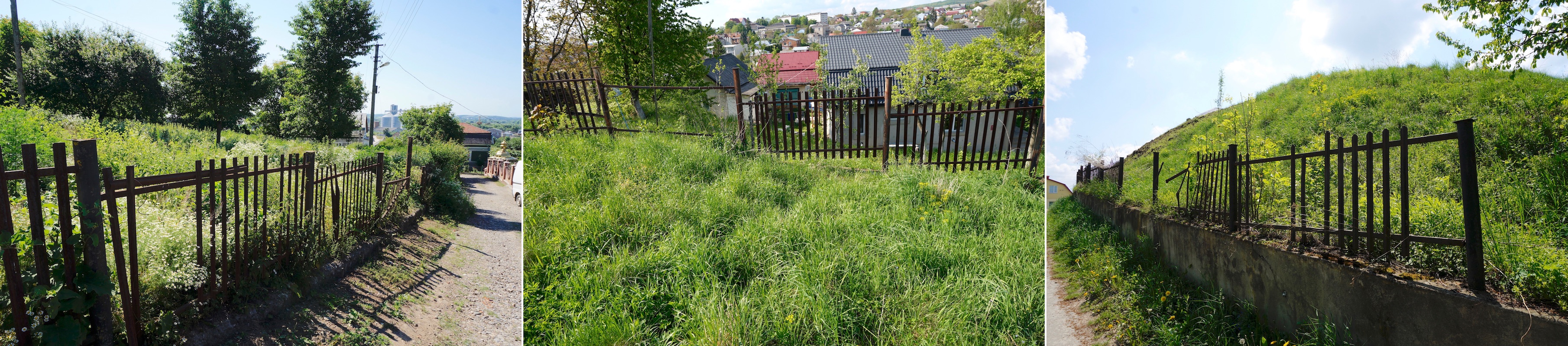
Three of the worst sections of the existing fence. Photos © RJH.
This rehabilitation project includes no plans or funding for repair or replacement of the existing fence which surrounds the old Jewish cemetery in Rohatyn, or replacement of the missing gate sections, but estimates the costs for future replacement.
The existing fence was installed in the late 1990s and is thus just over 20 years old. Constructed of stamped steel picket sections on a concrete retaining wall (two sides) and concrete pads (two sides), the fence has endured the wet weather common to the Opillya region with the loss of a few panels and many pickets to corrosion at the welded joints; gates have been lost at both ends of the cemetery to the same forces. Any future fence or wall and gate designs should account for the same weather effects, and budget accordingly. In the meantime, RJH will make minor repairs (simple strapping of loose sectional panels, and minor welding of support posts) on an as-needed basis, with no current plans for larger repairs or replacement. Keeping wild shrubs cut back from the fence annually should help reduce the stress on the existing fence, delaying the need for full replacement.
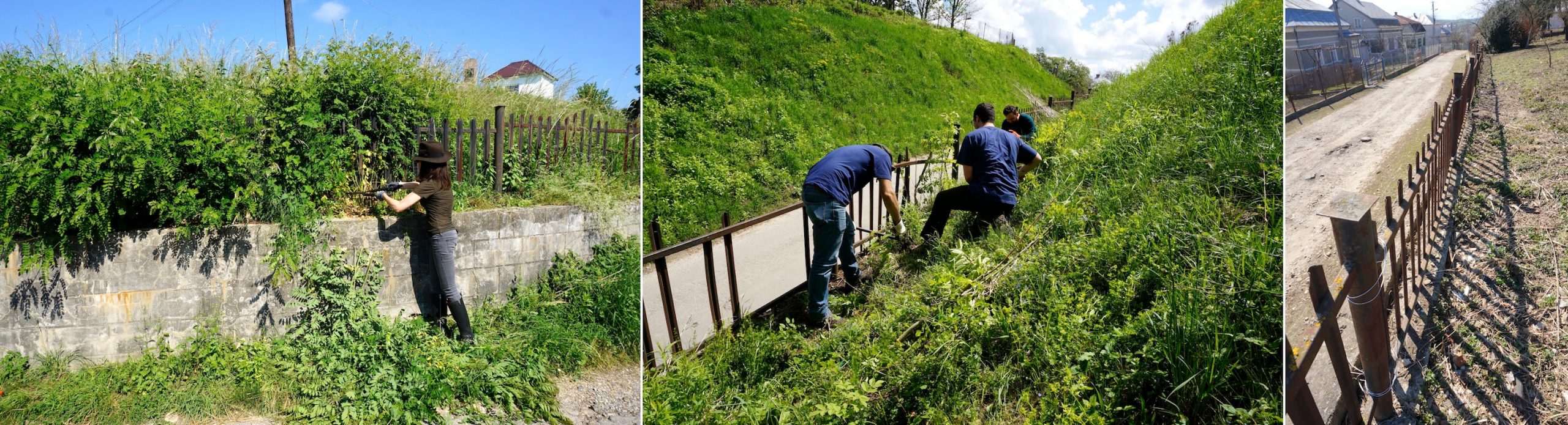
Cutting shrubs away from the fence to prolong its life, and wiring a loose panel back into place. Photos © RJH.
Cost estimates for future replacement of the perimeter fence assume that the existing concrete retaining walls and fence foundation would be retained but repaired or reconditioned, and that the metal fence itself would be replaced with another light and open but decorative metal picket-style sectional run in stamped steel or wrought iron between 1.0m and 1.5m high. Budgetary estimates for materials and labor for these types of fences, from similar projects managed by ESJF in western Ukraine and from large building materials markets in the region, range from US$20 to US$50 per meter plus gates and a small percentage for project management. At about 450m of cemetery perimeter, the overall cost to replace the fence is estimated between US$10,000 and US$25,000 depending on the fence style, durability, and issues encountered in the work. The estimated lifetime (time-to-replace) of a full-perimeter metal fence built onto a solid concrete foundation is estimated to range from 15 years for lightweight panels to 30 years for heavier (thicker) sections.
Sustainability Planning
Most facets of the overall old Jewish cemetery rehabilitation project are designed to reduce the cost and labor of recurring maintenance and component replacement. Where estimates of time-to-repair or time-to-replace can be estimated, those times are listed in the sections above.
In order to identify the occasional need for major repair or replacement of project features, ongoing inspection, clearing, cleaning, and minor repair work should be contracted or otherwise arranged at least once per year. These reviews can continue on a regular basis while RJH remains located in western Ukraine and can visit the cemetery several or many times per year, but planning for the long term will require identifying other resources to carry these tasks forward.
Project Support and Funding
Ukrainian friends working at one of the few standing matzevot. Photo © AP Photo / Yevheniy Kravs.
As noted in the concepts section above, the different project aspects (vegetation control, memorial monument, landscaping, headstone conservation, and signage) will be phased to spread the cost and management burden over time, while still presenting visible progress to the local and foreign public. Fundraising will be conducted for each aspect separately; the purchase of project materials as well as contract labor and administration will be gated by the availability of funds.
Project support for both materials and volunteer labor will be sought primarily where RJH has found resources for past projects: through individual charitable donations from Jewish descendants of Rohatyn families abroad, other interested Jewish and non-Jewish friends and colleagues (both local and foreign), and the city administration of Rohatyn. In addition, grants, funding, and/or discounted contract costs may be available through partnerships with Jewish NGOs which focus on heritage, the US State Department Embassy grant program in Ukraine, and other sources. Where the project work can be performed by volunteers working alongside us and contractors, we will again make a call to our reliable friends in the region, including the Lviv Volunteer Center, the Peace Corps, and others.
Communication and Public History
Raising public awareness and recognition of the old Jewish cemetery in Rohatyn as a site of shared heritage is a key part of this project for the Rohatyn Jewish Heritage NGO, and continues efforts by local historians, Jewish descendants, and NGOs around the world over the past decades. The task comprises several very different aspects, most of which are already complete or are continuously renewed :
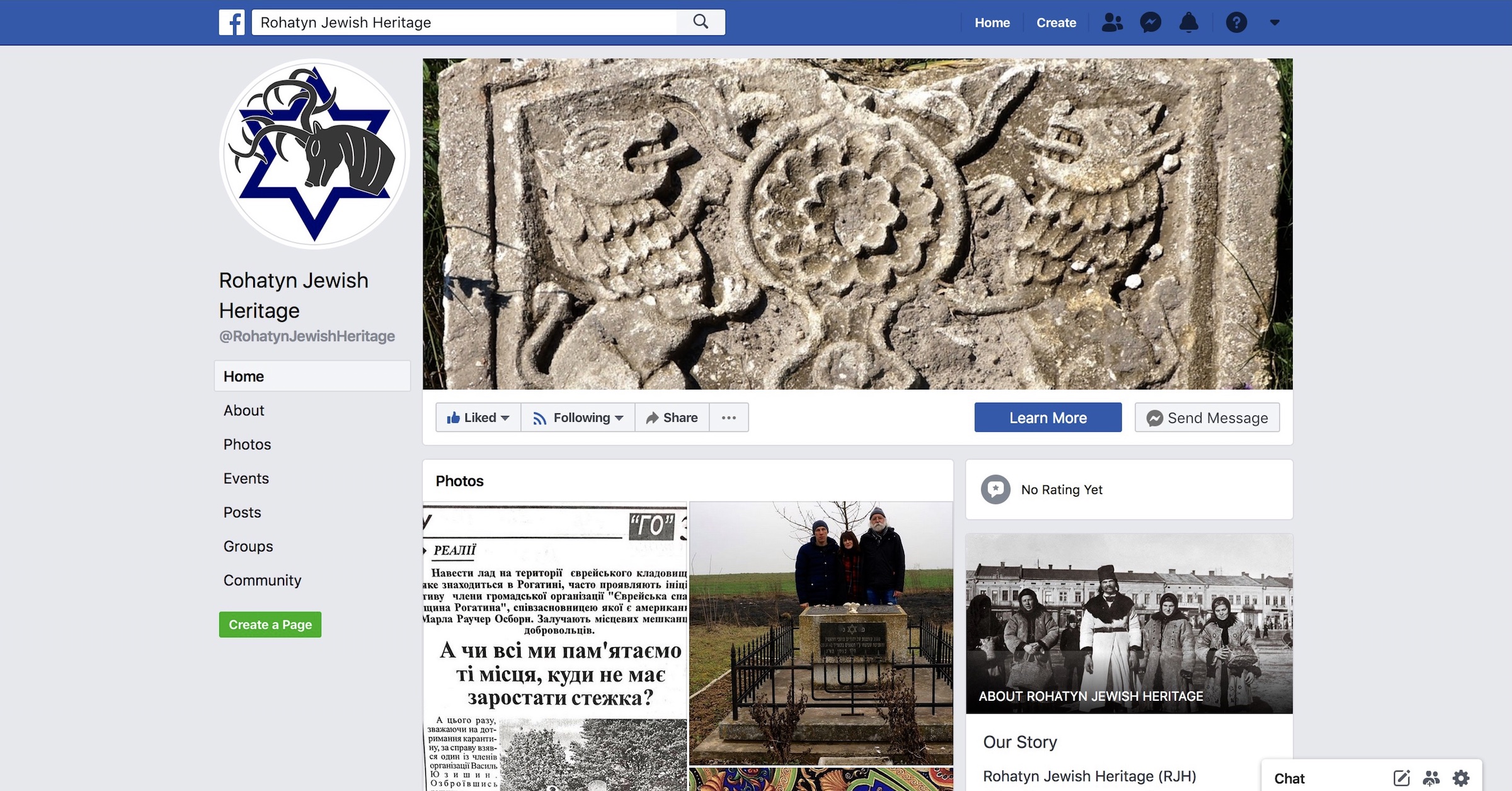
A screenshot of the RJH Facebook page.
RJH history and heritage website: This website has presented the history of the Jewish community of Rohatyn and its first burial site since 2015. This project page and the news section of this website continue to document designs and plans for rehabilitation as well as special events at the cemetery (cross-border tours and other visitors, volunteer clearing days, etc.). As noted above, QR codes on the multilingual information signs in the cemetery itself will also link to key pages on this website.
Social media and external blogs: Rohatyn Jewish Heritage actively maintains a public Facebook page which we use to promote the old Jewish cemetery as shared cultural heritage, to promptly report on clearing activities and other events in the cemetery, to publicize ongoing Jewish headstone recoveries to the old cemetery, and to announce upcoming events as calls for volunteers and other engagement. Through broad cross-posting to other Facebook groups and pages with focus on Jewish and Ukrainian heritage, genealogy, and history, we extend awareness and impact of this cemetery in key interest circles. Friendship and communication with colleagues who blog on related topics further extends awareness of Rohatyn’s Jewish past into their much broader circles, including for example Vanished World, Forgotten Galicia, and the Facebook page of the US State Department Embassy in Ukraine.
Other NGO websites and databases: Joint work and communication with a number of international NGOs have helped to spread awareness and information about Rohatyn and its built Jewish heritage, including the cemeteries. Valuable news and information specific to Rohatyn has been published online and/or in printed book form by Jewish Heritage Europe, the Shtetl Routes program of Brama Grodzka – Teatr NN, Ukrainian-Jewish Encounter, and The Matzevah Foundation. Databases which document the old cemetery and its features have been published online by ESJF European Jewish Cemeteries Initiative, the Center for Jewish Art at the Hebrew University of Jerusalem, and the Virtual Shtetl program of the POLIN Museum of the History of Polish Jews, often with input and data from RJH.
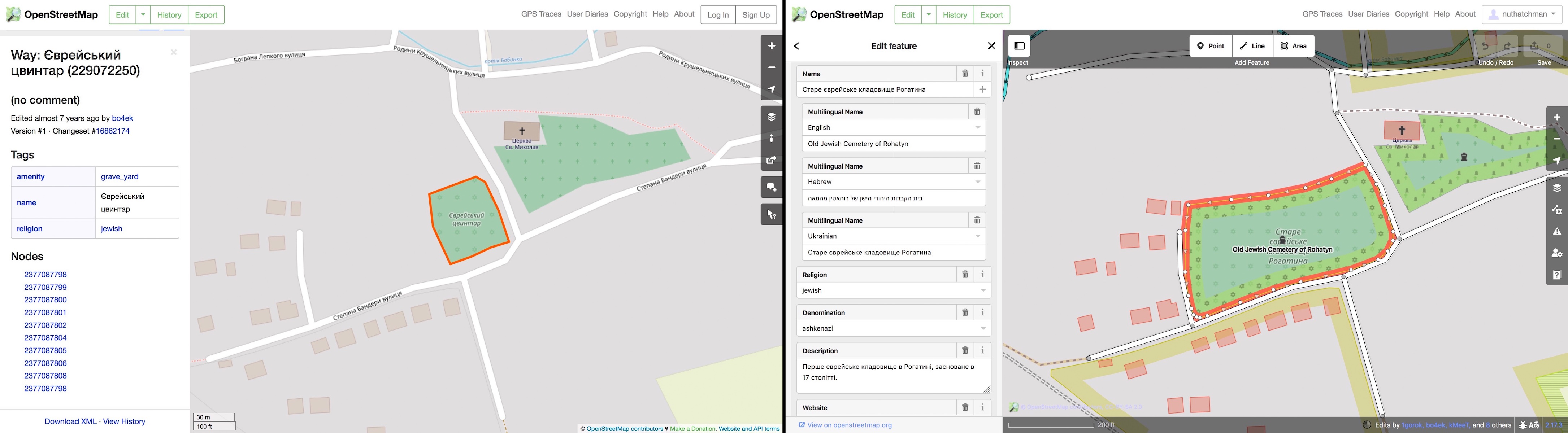
OSM internet map data of the old cemetery before and after an RJH edit to update boundaries, labels, and description. Images © OSM contributors.
Internet mapping databases: Many potential visitors to the cemetery, both local and from out of the region, may know nothing of this Jewish heritage website and other information sources. For people planning a virtual or physical visit to Rohatyn and its environs, trip planning often includes research on internet map sites, which pull details from a variety of curated commercial and crowd-sourced databases. RJH has submitted Rohatyn-specific heritage data (boundaries, names, descriptions, web links) to the databases which are open to inputs from users and registered editors, to help travelers and others discover and learn about the sites including the old Jewish cemetery. To date the most useful of these was a revision and expansion of the data on OpenStreetMap (OSM), a free open-source application and database which provides map data to its own and other desktop mapping applications as well as the very useful Maps.me mobile application which permits downloading of map data for use offline and is popular in Ukraine.
Local history museum: To help promote Rohatyn’s Jewish history and heritage in general, RJH partnered with the Rohatyn local history museum “Opillya” to jointly develop a small permanent exhibition with artifacts and other items donated by Jewish descendants, a video from the 1930s, and a large number of images, including of the old Jewish cemetery from the 2010s and an example recovered headstone.
Self-guided tour maps and information: One current commercial paper map of Rohatyn shows the old Jewish cemetery and other Jewish burial grounds marked as heritage sites, and a tourist guide to Rohatyn sold at the Opillya Museum also indicates the cemeteries. It is also possible for readers of this website to create their own driving and/or walking tours around all of the Jewish heritage sites of Rohatyn from a page which specifically presents an interactive map and GPS coordinates of the sites.
With Centropa seminar attendees at Rohatyn’s old Jewish cemetery. Photo © RJH.
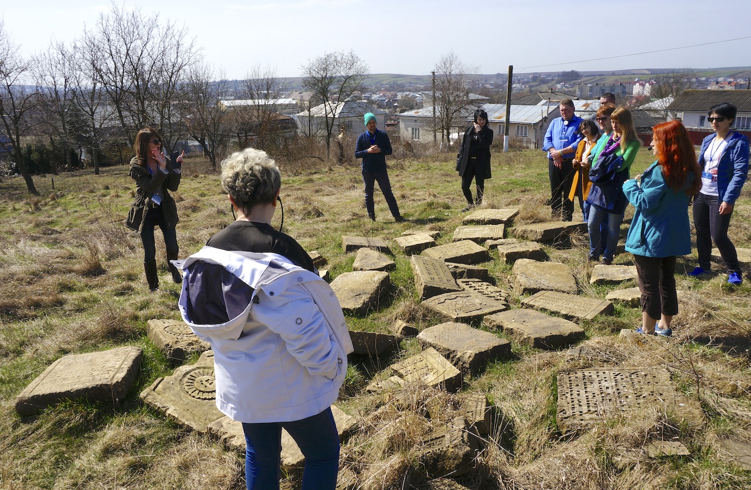
Regional tour guides: Most Lviv-based researchers and tour guides who include a focus on regional Jewish history are aware of the Jewish sites in Rohatyn, and many have already structured area tours to include visits to the cemeteries, especially the old Jewish cemetery and its recovered headstone fragments. In addition to these local resources, cross-border cultural heritage organizations including Rootka (an affiliate of Brama Grodzka – Teatr NN), Centropa, and the Galicia Jewish Museum of Kraków have organized specialized tours for educators and others to study and discuss the prewar history of the Jewish community of Rohatyn and the postwar transformation of its heritage.
Conferences, seminars, and other lecture events: The old Jewish cemetery of Rohatyn has appeared as a heritage object for diverse topics at several conferences in Europe for over five years, including twice at the Center for Urban History of East Central Europe in Lviv, in a discussion panel on heritage and memory organized by the Ukrainian Institute London, at two activist-organized round table discussions in Lviv, at an EHRI-organized Holocaust seminar at the Hesed-Arieh Jewish charity in Lviv, in two large European Jewish heritage conferences (in Kraków and Vilnius) organized by Jewish Heritage Europe and the Rothschild Foundation, and less formally at several gatherings and lectures for educators and high school students in Rohatyn.